A Deep Dive into our Region’s Fascinating Features
Contributing Writers | June 10, 2024 | 6 Comments
By Megan Pettey
The Appalachian Mountains, which are among the oldest mountains in North America, are abundant with magnificent natural wonders. Alongside a variety of gemstones and rare minerals, Appalachia is home to the New River Gorge and Seneca Rocks in West Virginia, intriguing salt deposits near Saltville, Virginia, breathtaking Chimney Rock in North Carolina, and so much more. Here’s a sampling of stunning geological features within the region.
Located 140 feet below ground in Sweetwater, Tennessee, lies the largest underground lake in the United States, known as the Lost Sea. This lake is part of the elaborate Craighead Caverns cave system, which hosts an abundance of gemstones and a rich, ancient history.

Lights illuminate the waters of the Lost Sea 140 feet below ground. Photo by William Trey Sullins
Explorers discovered the fossils of a prehistoric jaguar within the cave, and visitors have also found arrowheads and pottery belonging to the Cherokee Tribe, according to Lisa McLung, general manager of The Lost Sea Adventure, which currently owns the cave.
Named after Cherokee Chief Craighead, these caves once held tribal council meetings. Later, Confederate soldiers used minerals from the cave floor to make gunpowder during the Civil War.
The Lost Sea is fed by several underground springs and covers 4 1/2 acres, with the deepest point approaching 70 feet. The lake can rise and fall depending on how much precipitation the area receives. Pumps maintain water levels to avoid flooding the cave. Rainbow trout, introduced shortly after the lake opened to the public in 1965, swim through water illuminated by underwater lighting that gives the water a blue appearance.
The Lost Sea is home to over half of the world’s anthodites, which are long, needle-like crystal formations.
“[Anthodites are] formed from water that seeps through the rock and is mixed with aragonite crystals and calcite,” McLung says. “We call them flowers because they’re spiky and they can form in different colors, depending on what minerals are coming through the rock in that particular area.”
The full extent of the lake is unknown, as the convoluted cave system makes it difficult to explore even with modern technology. What is known is that there’s no shortage of geological and historical marvels for those who visit Craighead Caverns.
When most people think of craters, the image of a large, circular indentation in the desert comes to mind, or a “big bowl-shaped thing,” as Michael Hawkins puts it. Hawkins owns the Jackson County, Tennessee, property that contains part of the Flynn Creek Impact Crater. While this crater strays from the stereotype, it remains captivating.
“Geologists find evidence of structures that they suspect are craters, but this one is known and scientifically proven to be an impact crater,” Hawkins says. “And just those two words, impact crater, mean a whole lot in the world of geology, because a lot of places show cryptovolcanic evidence or evidence of some kind of disturbance, but this one we know has happened from a thing that came from space and hit the Earth.”
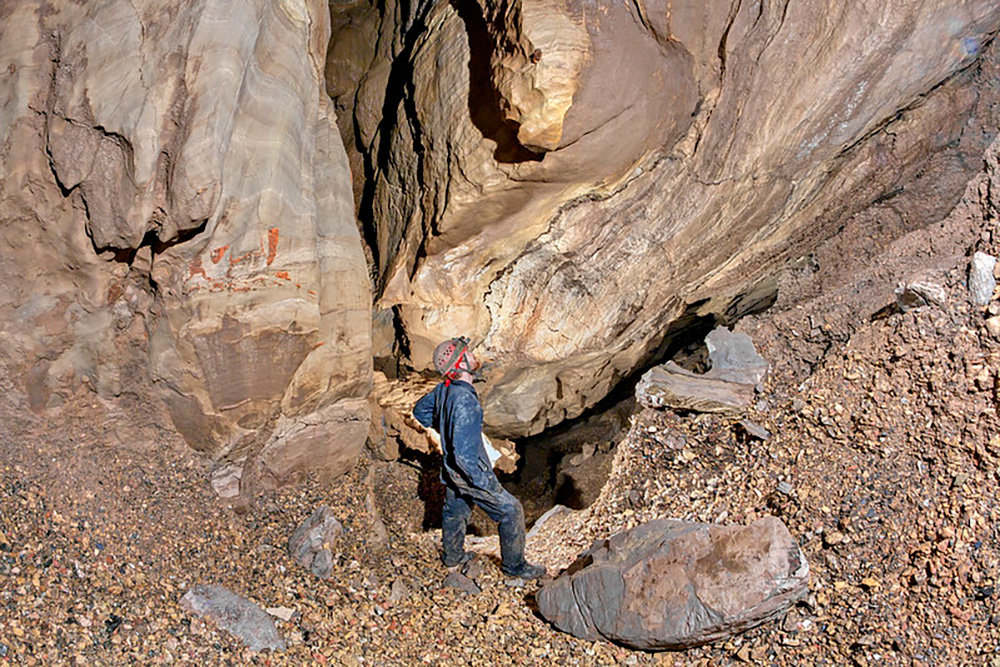
Explorer Clinton Elmore stands at the Hawkins Impact Cave, named after its discoverer Michael Hawkins. The cave is one reason why geologists from around the world are drawn to the Flynn Creek Impact Crater. The crater has long been a vibrant site for research, and NASA used the site to train astronauts for Apollo missions prior to the first moon landing. Photo by Chuck Sutherland
Spanning 2 miles in diameter and originating about 360 million years ago, the Flynn Creek Impact Crater is preserved underneath layers of stone, with portions of the crater visible via the creek. Such well-preserved instances of impact craters are extremely rare, as most evidence of surface anomalies like this one have been lost to erosion. Luckily, a sediment from the Chattanooga Sea, a calm body of water existing hundreds of millions of years ago, created a protective layer of shale that preserved the crater’s impact on the land. Millions of years after that, Flynn Creek developed and eroded through the layers of shale, exposing segments of the crater. Adding to the rare nature of the crater is the Hawkins Impact Cave, which is the only known cave in the world to occur in the central uplift of any meteor or impact crater.
“What a central uplift is, it’s like a great big example of a pebble being dropped in water, how the water splashes back up in the middle of the thing, except this was stone that splashed back up,” Hawkins says. “It kind of became plastic when this thing hit.”
Energy company Enbridge is currently threatening the preservation of this geological site with the proposed Ridgeline Pipeline. The 122-mile methane gas pipeline would run through eight Tennessee counties to provide fuel to the Tennessee Valley Authority’s proposed Kingston gas plant. The construction would go directly through the central uplift and the watershed of Hawkins Impact Cave. Appalachian Voices, the organization that publishes The Appalachian Voice, is working closely with community members to urge TVA to consider clean energy alternatives and stop Enbridge from constructing the pipeline.
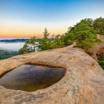
With sweeping vistas and one of the deepest chasms in the Eastern United States, North Carolina’s Linville Gorge in Burke County rightfully earned its nickname as “The Grand Canyon of the East.” Jonas Ridge to the east and Linville Mountain to the west form the chasm, which plummets roughly 2,000 feet to the Linville River. Rock formations such as Hawksbill Mountain, the Chimneys and Table Rock stand out in the steep, ragged terrain.
Primarily composed of quartzite, a metamorphic rock, the jagged horizon of Linville Gorge is a sight to behold. Logging proved extremely difficult in the rugged gorge, resulting in an abundance of old growth trees.
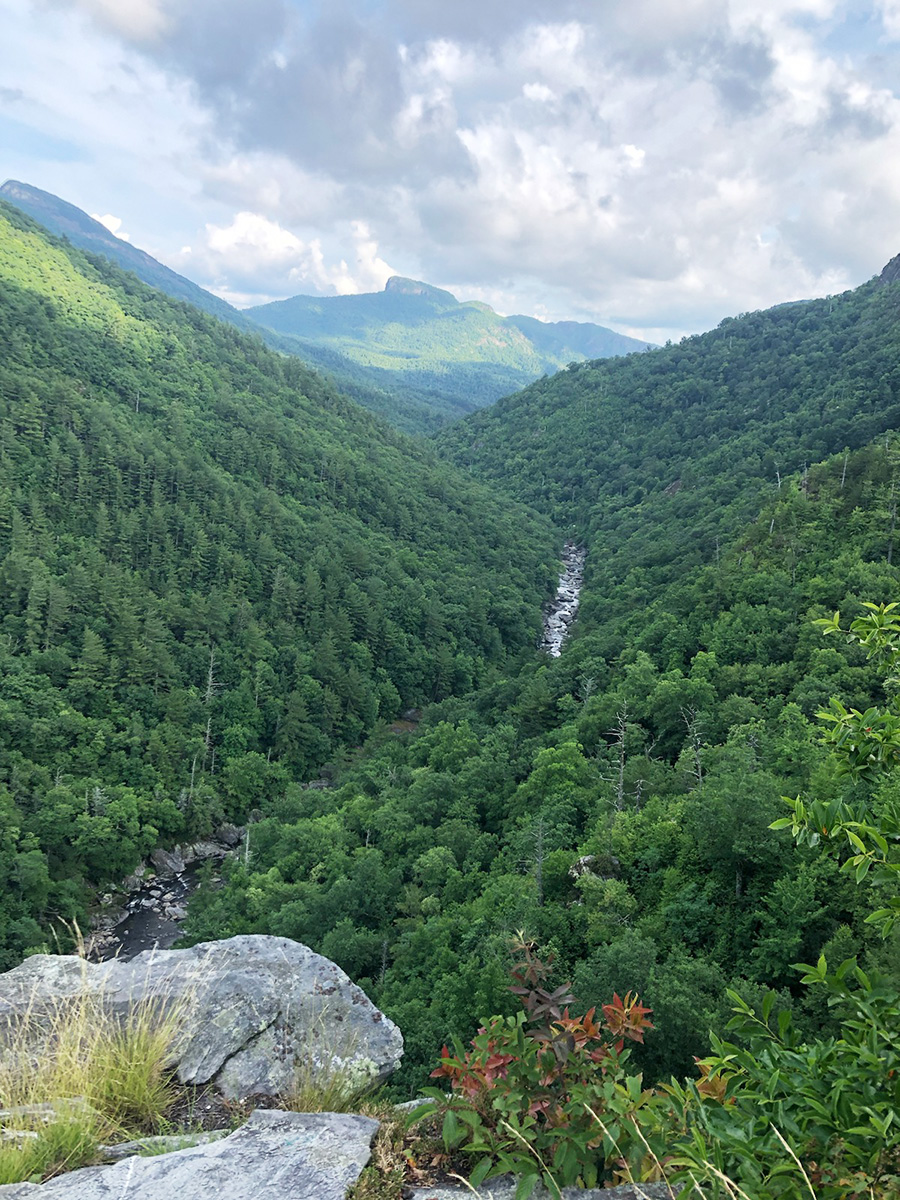
Table Rock juts out above the Linville River in Linville Gorge Wilderness Area. Trails in this area are often steep and unmarked. Photo by Megan Pettey
The dramatic steepness of Linville Gorge fascinates many, including Brad Johnson, associate professor of Environmental Studies at Davidson College, who discovered that a phenomenon called stream capture created the chasm. Stream or river capture occurs when a stream with a lower-elevation base captures and diverts a higher-level stream.
“It turns out that basically all the streams that are north of Grandfather Mountain used to flow to the west into the Toe River, and then the Linville captured those rivers and for that reason they pulled a lot more water through them,” Johnson says. “It’s like three times more water as soon as that capture is made. And so now you have all this extra energy eroding down into the gorge and creating the gorge.”
Johnson sought physical evidence to prove this idea, which he found in the form of gravel deposits produced by streams. In May 2020, Johnson located large gravel deposits containing quartzite in places where there aren’t rivers today, which he claims confirmed a stream capture indeed took place millions of years ago.
Considering the remarkable nature of Linville Gorge and its astounding beauty, it’s no wonder this designated wilderness area is an outdoors hotspot.
Among Virginia’s spectacular natural wonders, Natural Tunnel in Scott County features a looming tunnel almost 100 feet tall arising from the powerful forces of erosion.
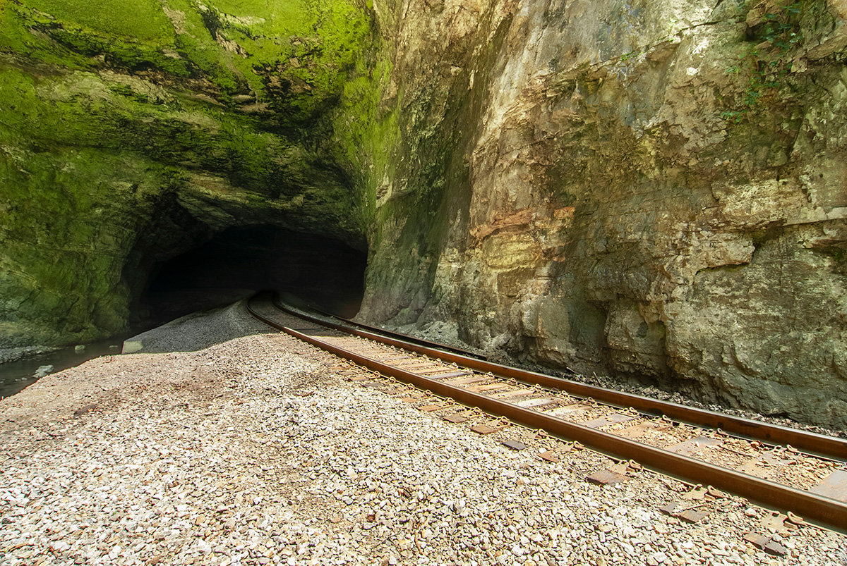
Railroad tracks run through the nearly 100-foot-tall and 850-foot-long Natural Tunnel in Virginia. Photo by Jason Barnette.
The formation of this 850-foot-long site is attributed to subterranean stream capture, which took place when the upper reaches of Stock Creek flowed into a cavern that would eventually become Natural Tunnel. The force of the water eroded through limestone, creating the grand passageway that would later be a vital transportation route for both Union and Confederate soldiers.
Visitors to Natural Tunnel State Park can take a boardwalk to the tunnel entrance and feel the cool breeze coming from the shadowy interior of the tunnel.
Norfolk Southern trains run this route daily, but once per year on Railroad Day, the trains pause so that hikers can explore the tunnel’s interior. Intricate rock layers form patterns on the tunnel walls, evidence of the transformative forces of water over time. Railroad Day is typically the third Saturday in July, but visitors should call ahead to confirm.
In the heart of Virginia’s Shenandoah Valley lies a 215-foot-tall limestone wonder known as Natural Bridge. This renowned archway is located at the center of a gorge carved by Cedar Creek, which flows beneath the towering bridge. An estimated 500 million years old, this formation dates back to the Ordovician period and is part of the Beekmantown formation.
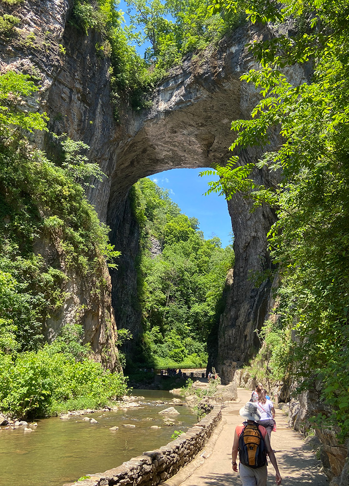
Virginia’s 215-foot-tall arch known as Natural Bridge is a sacred site for the Monacan Indian Nation. Photo by Dan Radmacher
The powerful forces of Cedar Creek eroded through limestone over time, creating the captivating Natural Bridge. Covered in lush vegetation, the bridge has long been a sacred site for the Monacan Indian Nation. Thomas Jefferson purchased the Natural Bridge in 1774, and the initials “G.W.” carved into the bridge feed the unconfirmed rumor that former President George Washington also visited this stone beauty. The site was a source of inspiration for many landscape artists in the 19th century — the abundance of artwork featuring the glorious arched passageway is a testament to its natural splendor.
Natural Bridge State Park opened in 2016 and has far more to offer than the bridge itself. Visitors are drawn to the beloved Lace Falls, which provides an idyllic setting for soaking in the sights and sounds of nature. Among the park’s diverse trails is the universally accessible Cedar Creek Trail, which includes a wheelchair lift and complimentary shuttle — visitors should call ahead for accessibility accommodations.
Nestled in Pocahontas County, West Virginia, is Cranberry Glades Botanical Area, which protects the largest area of bogs in the state within a stunning 750 acres. While most bogs in the United States are found farther north, the last glacial period gifted this ecosystem a special home in West Virginia.
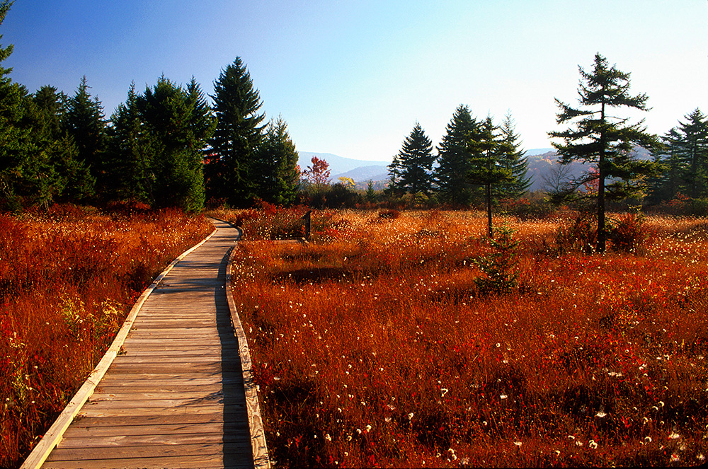
Tawny cotton grass is one of the many blooming species found along the half-mile boardwalk in Cranberry Glades Botanical Area. Photo courtesy of USDA Forest Service
Cranberry Glades formed over 10,000 years ago, according to Rosanna Springston, a representative of the Gauley Ranger District of Monongahela National Forest, which encompasses the glades. At that time there was little vegetation and a lot of moving water pushing sediment, Springston explains. This formed embankments along the streams and gradually created four large ponds.
“Then fast forward a little bit, the water became still and sphagnum moss and other plants moved in, and that’s what started the Cranberry Glades as we know it now,” Springston says. “So it formed, essentially, what ended up being Long Glade, Big Glade, Round Glade and Flag Glade.”
These names refer to the four bogs within Cranberry Glades, which are wetlands composed of decaying plant materials, typically sphagnum moss. This environment provides ideal habitat for carnivorous plants, such as the pitcher plant and the sundew. Both small and large cranberries are abundant, as well as eight species of orchids.
“This is the southernmost point for a lot of species, things that you would usually have to find a lot further north,” Springston says. “So we’re looking at things like bog rosemary, oblong fruit serviceberry, Jacob’s ladder, buckbean, northern coralroot. You’d have to travel much further north to be able to find those.”
A half-mile boardwalk allows visitors to easily admire the bogs without disturbing the precious ecosystems. Springston notes that Cranberry Glades is also an excellent spot for birding.
“The main tip I have for any visitor is to take their time and be very patient on their journey around the boardwalk, and let nature reveal herself to you,” Springston says.
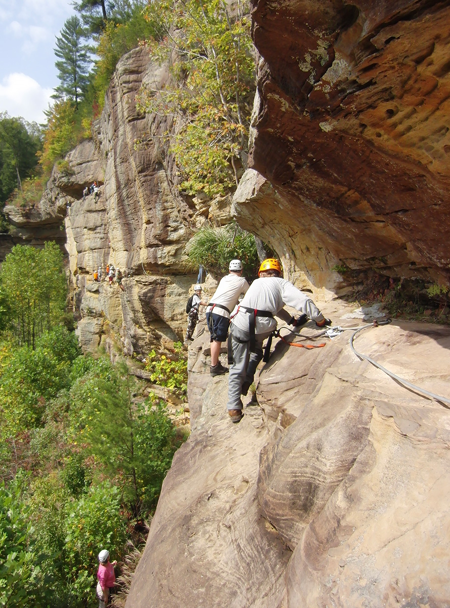
In Daniel Boone National Forest, Kentucky’s Red River Gorge has long drawn travelers with its impressive sandstone arches, steep cliffs and gushing Red River.
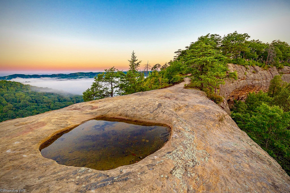
Auxier Ridge is part of a trail network that offers views of landmark rocks and arches. Photo by Brandon Jett
The sandstone cliff formations and exposed limestone rock faces populating Red River Gorge date back over 300 million years to the Paleozoic era. Sand and sediment deposited in ancient seas formed these sedimentary rocks, which were later uplifted and exposed through tectonic activity. Erosion from wind and water carved out the deep valleys and cliffs visible today.
Visitors can choose to enter the gorge via Nada Tunnel, a 900-foot limestone tunnel constructed in 1910 to transport lumber. Within the gorge there are over 100 natural sandstone arches.
An extensive network of caves are hidden beneath the gorge, primarily composed of limestone and dolomite. Entering the caverns is currently prohibited in an effort to minimize the spread of white-nose syndrome, a deadly fungal disease that kills hibernating bats.
Steep cliffs, sandstone arches and the Red River draw adventurers to the Red River Gorge. Photo by Troop 199 Fishers, IN is licensed under CC BY 2.0
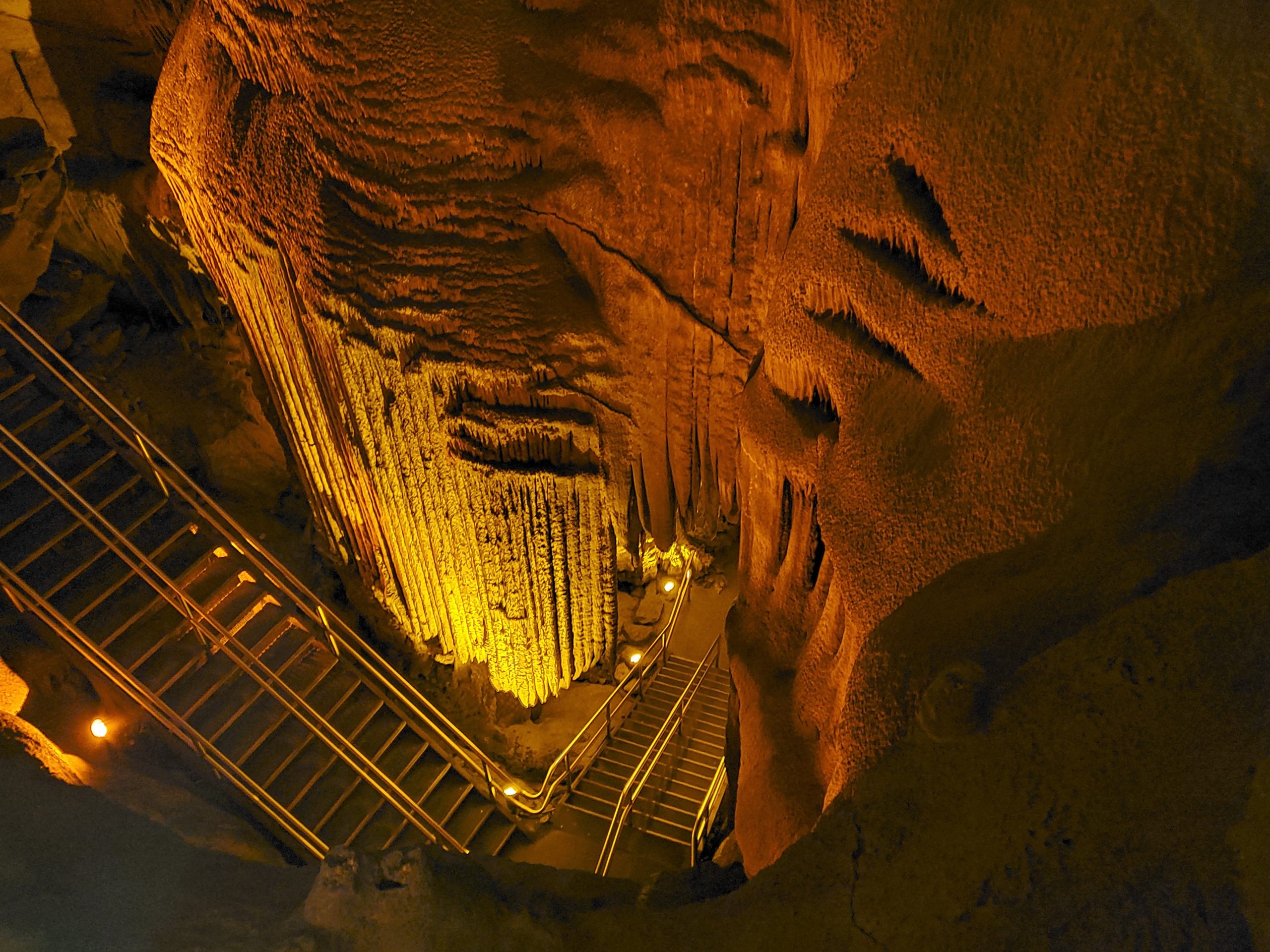
Though technically situated just outside the Appalachian region, Mammoth Cave National Park deserves an honorable mention for housing the world’s longest known cave system. Located in south-central Kentucky, this 426-mile-long cave system is a designated UNESCO World Heritage Site and an International Biosphere Reserve.
Various types of passageways populate Mammoth Cave, the tallest of which are canyon-type passageways, which can be between 30 to 40 feet wide and 50 to 60 feet high, and in some places even higher, according to Supervisor Park Ranger Johnny Meredith. The cave also contains flowing subterranean rivers and white gypsum crystals that grow as “flowers” in petal-like shapes from cave walls.

The mineral gypsum thrives in dark areas of caves, sometimes forming flower-like formations as it grows outward from cave walls. Photo courtesy of Thomas DiGiovannangelo at the National Park Service.
Formed by the Green River’s erosion of limestone bedrock between 10 million and 3 million years ago, the sedimentary rock Mammoth Cave formed from dates back 330 million years to the Mississippian era. Once submerged beneath a shallow, tropical sea, according to Supervisor Park Ranger Johnny Meredith, many marine fossils like brachiopods, coral and shark teeth have been unearthed within the cave.
Various types of passageways populate Mammoth Cave, the tallest of which are canyon-type passageways, which can be between 30 to 40 feet wide and 50 to 60 feet high, and in some places even higher, according to Meredith. The cave also contains passageways with flowing subterranean rivers, vertical passageways that are nearly 100 feet tall, and tubular passageways decorated with white gypsum crystals that grow as “flowers” in petal-like shapes from cave walls.
“Conversely, we also have very tiny passageways where cavers may have to exhale all the breath out of their body to compress their chest small enough to pop through a hole to get to the other side of a particular area,” Meredith says. “So it’s quite a contrast in that respect.”
The flowstone formation known as “Frozen Niagara” as seen from above within Mammoth Cave. Photo courtesy of David Kem at the National Park Service.
Hanging from cave ceilings like stoney icicles or creeping upwards from cave floors are deposits known as stalactites and stalagmites. Stalactites are formed when water dissolves limestone and re-deposits calcium carbonate. As they form, water drips below to create stalagmites, a mound that rises from the cave floor. These structures can form a column if they eventually meet in the middle as water continues to drip.
Redeposited limestone also decorates the cave in another eye-catching form known as flowstone features, resembling frozen stone waterfalls hanging like curtains draping cave walls.
“These flowstone areas are not necessarily where the water has been dripping out from the ceiling to form a stalactite or falling onto the ground for a stalagmite,” Meredith says. “But maybe it’s been running down the side of the wall. And now it’s coating the wall or it’s coating rocks on the bottom of the cave floor and can have these floating sheets of stone is kind of what they look like after they’re deposited.”
Mammoth Cave is a never-ending source of wonder, and well worth the trip for those seeking amazement in natural landscapes, according to Meredith.
Correction: June 10, 2024
This article has been updated from the original print version to reflect that the Appalachian Mountains are among the oldest mountains in North America, the metamorphic quartzite rock at Virginia’s Natural Bridge dates back to the Ordovician period and the sedimentary rock in Mammoth Caves dates back to about 330 million years ago. Additionally, groundwater began carving out the caves from about 10 million years ago to about 3 million years ago. Unfortunately, these corrections could not be made in the print copies. The Appalachian Voice regrets the errors.
Correction: June 17, 2024
This article has been updated to reflect that Linville Gorge is in Burke County, North Carolina. The Appalachian Voice regrets the errors.
Like this content? Subscribe to The Voice email digests
![]()
![]()
![]()
![]()
![]()

The Appalachian Voice is a publication of Appalachian Voices
589 West King Street, Boone, N.C.
© 2021 Appalachian Voices


I really enjoyed this article. It brought back a story I read years ago about a mountain cave in West Virginia, I believe. It was in “Good Old Days” magazine. The writer told about being a child picnicing near this cave, cavern and making ice cream. The ice came from the cave. According to her story the cave was full of ice. In the summer you could make ice cream or keep you picnic cold. Have you heard or seen anything about this?
The Linville Gorge is completely in Burke County.
Good article.
Pennye Barry
Probably the place called Ice Mountain in West Virginia.
https://en.m.wikipedia.org/wiki/Ice_Mountain
The section about the Flynns Creek impact crater left out an important piece of information. No one is proposing a new pipeline. They are proposing to install a second larger pipeline right next to an existing pipeline. A natural gas pipeline has run thru this area for years.
Hi Joseph. The second pipeline is a new pipeline that will require additional clearing in many places for right of way and construction easements. This new construction threatens impacted environmental habitat and geologic features, and poses additional safety concerns for nearby residents.
Hi Shawn, Thank you for bringing that to our attention! We’ve made the correction in the text.