Follow Us on Twitter: Appalachian Voices | iLoveMountains.org

Archive for the ‘2011 – Issue 3 (June/July)’ Category

The Coal Report

Monday, June 13th, 2011 - posted by Meg

Controversy over Coal Jobs, Mercury Poisoning and Liquid Coal

By JW Randolph

The often slow pace of progress in Washington D.C. hasn’t stopped the Obama Administration—or a divided Congress—from continuing an uproarious debate about coal, carbon and climate in the first half of 2011.

In May, a House of Representatives subcommittee held a two part hearing on “mining issues,” titled “EPA mining policies: Assault on Appalachian Jobs.” Water Resources Subcommittee Chairmen Bob Gibbs invited nine witnesses, only one of whom represented the EPA. The other eight witnesses, many of them representing large donors to Gibbs’ election campaign, all held pro-mountaintop removal positions. No impacted citizens, regional scientists, or Appalachian economists were invited to speak on the panel.

Nevertheless, Appalachian citizens who oppose mountaintop removal came and filled the hearing room on both occasions, wearing buttons that said “I Love Mountains” and “Stop Mountaintop Removal.” Citizens were able to speak directly with Chairman Gibbs and other members after the hearing to express their displeasure at being excluded from the public process.

Despite a decades long decline in mining jobs across central Appalachia and a recent national recession, Appalachian mining jobs have actually grown in the last four years—largely due to the fact that central Appalachian coal operators are using a larger percentage of deep-mining to get their coal. Deep mining currently provides 50 percent more jobs than surface mining in Appalachia.

In other news, the EPA is currently taking comments on the regulation of mercury and other toxic emissions from power plants.

As little as one gram of mercury falling on a 20-acre lake over the course of a few years is enough to make fish unsafe for human consumption. Despite this fact, 48 tons of poisonous mercury are emitted by coal-fired power plants in the U.S. every year, falling into lakes and rivers through rain. The effects of mercury ingestion range from headaches and skin rashes to severe neurological damage.

The comment period is open until June 5th.

In addition, a group of Representatives recently introduced legislation to incentivize the production and use of liquid coal for fuel. Increased domestic gas prices have brought this controversial topic back to the Hill. There has been no word on whether legislation will pass, or when it would move.

TVA Retires 18 Power Plants

By Jeff Deal

On April 14, the Tennessee Valley Authority (TVA) announced its intention to retire eighteen of its oldest, most polluting coal-fired power plants. By the end of 2017, the TVA will have retired 2,700-megawatts (enough for between one and three million homes) of coal-fired electricity generation. The TVA says it plans to replace this generation with “low-emission or zero-emission electricity sources, including renewable energy, natural gas, nuclear power and energy efficiency.”

An agreement between the TVA, the EPA, three U.S. states and three environmental advocacy groups stipulates that the TVA spend $350 million dollars to develop energy efficiency and environmental restoration projects. The TVA also agreed to protect TVA customers from the long-term risks of any single fuel source.

Appalachia Rises For Blair Mountain

By Jillian Randel

On the week of June 4-11, citizens will march, rally and participate in a day of action to preserve Blair Mountain, abolish mountaintop removal, strengthen labor rights and demand investment in sustainable job creation in Appalachian communities.

This summer’s Appalachia Rising event will commemorate the 90th anniversary of the Battle of Blair Mountain. In 1921, 10,000 miners rose against coal operators to demand the basic right to live and work in decent conditions.

The event will kick off with a celebration concert to honor the life and legacy of West Virginia music legend Hazel Dickens on Sunday, June 5 at 7 p.m. at the Culture Center in Charleston, W.Va. All proceeds benefit the March on Blair Mountain. Tickets are $15 and can be purchased at blairmountainconcert.eventbrite.com.

UBB Disaster Was “Preventable”

By Jeff Deal

Tasked with discovering the cause of the disaster that killed 29 Appalachian miners on April 5, 2010, the West Virginia Governor’s Independent Investigation Panel found, “the disaster at Upper Big Branch was man-made and could have been prevented had Massey Energy followed basic, well-tested and historically proven safety procedures.”

The disaster was the result of a failure to comply with three basic underground coal mining safety practices: maintaining a proper ventilation system, following federal and state rock dusting standards and maintaining the safety systems of coal mine machinery. Over 14 mine employees and high level managers of Massey Energy declined to provide information for the independent review of the disaster.

Newsbites from Coal Country

Destruction is Not Development

A recent study by the Ochs Center for Metropolitan Studies found that just over half (56%) of the jobs promised by six new coal plants were actually created.
Peer-Reviewed Report Questioning Climate Change Earns an “F”: The 2008 report came under question when sections of the federally funded study were found plagiarized from the Internet Encyclopedia, Wikipedia and student textbooks.

Tennessee Mountain Lovers Seek to Keep Their Cumberland Mountaintops

The state of Tennessee filed a “Lands Unsuitable for Mining” petition on October 1, 2010 in an effort to keep the lands and ridgelines within the Cumberland Plateau designated for public use free from surface mining. The petition is now under review by the U.S. Department of Interior.

Coal Gets School House Rocked

The educational materials provider, Scholastic, recently came under fire for their fourth-grade lesson packet entitled “The United States of Energy”, produced primarily with funds from the American Coal Foundation. Critics note that the educational piece failed to address any of the detrimental effects of coal use such as air and water pollution, human illness and environmental degradation from coal mining.

West Virginians Meet with Coal Operator, Alpha Natural Resources

Residents asked Alpha to consider safer blasting and to switch to a dry method of coal processing, abandoning the wet process that creates coal slurry that poisons nearby drinking water. In a surprise ending, Alpha’s CEO requested a follow-up meeting in July.

Seeing the Forests Because We Left The Trees

Monday, June 13th, 2011 - posted by Meg

Harper's Creek Trail, Pisgah National Forest, NC. Photo by Jamie Goodman.

Harper's Creek Trail, Pisgah National Forest, NC. Photo by Jamie Goodman.


By Jamie Goodman

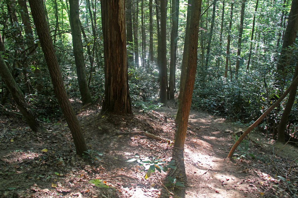
The region of central and southern Appalachia has more national land of any other region east of the Rockies.

If you combine just two of our eight national forests—the adjacent George Washington and Jefferson national forests—you have one of the largest chunks of public land in the eastern U.S. That region encompasses 39 counties in Virginia, West Virginia and Kentucky and includes notable spotlights like Shenandoah National Park, Rapidan Wildlife Management Area and Douthat and Grayson Highlands state parks. With 2,193 hiking and biking trails—including 330 miles of the Appalachian Trail—in these two forests alone, even the most rabid eco-tourist should have plenty do to for a while.

The parks and forests of Appalachia bring tourism, and tourism brings tourist dollars which help to boost the economies of our small mountain communities. Areas that had no major industry or relied on agriculture or a single industry before the 1970s have either dwindled or flourished, depending on which side of the tourist fence they now stand on.

After the railroads were closed in the late 1970s, the construction of the 34-mile Virginia Creeper biking trail on an old railroad bed and the embracing of Appalachian Trail thru-hikers virtually transformed the dying town of Damascus, Va., into an outdoor mecca today, complete with an annual Trail Days Festival which draws thousands of visitors.

“The trail competely changed [Damascus] from empty store fronts to a bustling town,” said Nancy Lamb, an active resident also known by some as Mrs. Damascus. “The difference was the leaders who put it together. They were very farsighted.”

In contrast, the small hamlet of Lansing, N.C.—located on the same old railroad line as Damascus—elected not to continue the Creeper Trail into their area. Today, Lansing storefronts sit empty and the once charming mountain town has a sad, neglected feel.

But although we have a wealth of state and federally-designated land, Appalachia is also faced with serious issues that threaten the tranquil beauty that has helped some communities prosper.

In the eastern part of West Virginia, near the George Washington National Forest, mining towns like Fayetteville and Ansted experience economic stability and diversity in spite of the mining threatening their towns, thanks to the yearly influx of hikers, kayakers, climbers and car campers that come to the national forest and New River Gorge area to vacation.

Yet if you look at map of western West Virginia or eastern Kentucky—where mountaintop removal coal mining is the most prevalent—you would be hard-pressed to find much of the green that designates national and state forests or parks. If you compare this to a map outlining the most poverty-stricken areas in those states, the correlation would be strikingly clear.

Towns like Benham, Ky., which once grew a thriving tourism trade, are now being threatened as dwindling coal supplies force companies to move extraction sites closer to populated areas. Outdoor recreation destinations such as Boone, N.C., cave to pressure from state agencies against items such as providing bike lanes to enhance the town—perks that would elevate Appalachian towns to rival the tourist meccas of the country’s western states.

But as long as the blue and green misty mountains of Appalachia stand strong, people will come.

People will come to escape the heat of the southern cities, to let the cool mountain breezes and soft summer clouds invade their senses. People will come to sit beneath majestic old trees and peer deep into the valley far below, to contemplate how small they are in this enormous world. People will come to wade in our streams and marvel at the cold, crisp waters, to listen to mountain music and to revel in the ethereal, eternal and ancient beauty that is Appalachia.

Yes, as long as we preserve our mountains, people will come.

Editorial and Viewpoint

Monday, June 13th, 2011 - posted by meghan

Blair Mountain: Preserving Our History, Our Integrity

“And if all others accepted the lie which the Party imposed—if all records told the same tale—then the lie passed into history and became truth. ‘Who controls the past’ ran the Party slogan, ‘controls the future: who controls the present controls the past.’” — 1984, George Orwell

Few things can be considered more contemptible than the deliberate and systematic erasure of history. It is dishonest to our future generations, an act unworthy of free people in a democratic republic.

Early this June, a week-long march will take place to stop the destruction of a national historic monument in West Virginia. The cause these marchers represent deserves a lesson in every U.S. classroom.

Blair Mountain was the site of an armed confrontation between tens of thousands of miners and coal company mercenaries in 1921. It was the largest armed conflict in the United States since the Civil War, triggered by a long series of grave injustices endured by generations of Appalachian miners.

For 15 years, the Blair Mountain site has been strongly recommended for national preservation by historians working for the U.S. National Park Service and a large number of archaeologists, labor historians and historical societies of the highest caliber. As a result of their work, the Park Service finalized the national designation of Blair Mountain as a protected historic site in March of 2009. That should have been the last word.

Instead, in November of 2009, the State Historic Preservation Office of West Virginia requested that the site be “de-listed” due to a set of transparently flimsy technicalities. The Park Service capitulated in January 2010, and “de-listed” Blair Mountain. Historians and citizens were shocked.

Blair Mountain is standing in the way of mountaintop removal coal mining; and how convenient for the coal industry—destroying a reminder of its sad and shameful history of labor and environmental injustices.

Not surprisingly, lawsuits have been filed and outrage, grief and sheer disbelief have filled the blogs and op-ed columns.

After all, erasing history is what made George Orwell’s “big brother” government so despicable in his novel “1984.” Erasing history was one of the great crimes, among many, of Soviet communism. Contempt for history is why there will always be a profound disconnect between Americans and the governments of communist China, Libya, Saudi Arabia, Burma and far too many others.

This June of 2011, a peaceful assembly of our fellow Americans will walk the route taken by the miners marching to Blair Mountain that summer 90 years ago.

It is our highest hope that the National Park Service and West Virginian “historians,” now in a position counter to their noble charter and Our Nation’s highest principles, will join in solidarity with these Blair Mountain marchers at their journey’s end.

For more info, visit marchonblairmountain.org.

Cartoon: "There's no App for this" Picture of man fishing.

Caring for the Earth So That We May Care for Each Other

Excerpted from a sermon
by Rev. Pat Watkins

Creation care is not just about caring for the earth. It is about caring for one another. Human beings are also a part of God’s beloved creation. Nearly every human struggle comes back to the earth in some way. Wars have been fought over land, oil, water, access to ports or control of shipping routes. Infants die for the lack of clean water. We cannot care for our fellow human beings without caring for the earth. We lament for all the humans God has created and especially for those who suffer due to the misuse of creation by those who choose to ignore the consequences of our wealthy lifestyles.

It’s so easy to dwell on the trouble part, isn’t it?

But even when we lament what is happening right now, it puts things into perspective to remember just how good God has been to God’s people throughout the ages. Colossians talks about all of creation being rescued, of being saved, of Christ being the redeemer of all that God has created. John talks about Christ being present with God at creation. How can we not believe that God will continue to love and care and heal His own creation?

I hate to admit this, but part of the tension for me is the knowledge that I am so very passionate about healing the earth while at the same time I realize that I am part of the problem. I stay torn between lamentation and praise.

Bishop Donald Ott, a retired United Methodist Bishop from Michigan, says it like this: “We cannot help the world until we change our own way of being in it.”

Whenever I think of a vision of faith and hope, I think of the vision of the Kingdom of God; I think of God’s will being done on earth as it is in heaven. I see no gap between the rich and the poor. I see everyone with enough to eat; I see clean water, enough for everybody. I see air that doesn’t give children asthma. I see the Chesapeake Bay full of crabs and oysters. I taste tomatoes that actually taste good. I see renewable sources of energy. I see species of animals that are not faced with their own extinction. I see farms instead of shopping malls. I see rice that can actually reproduce. I see pigs and cows and chickens that can actually hang out in the fields. I see turkeys whose breasts are small enough so that their legs do not break.

I see solar panels on roofs of homes and churches. I see new forms of transportation that don’t rely on oil. I see glaciers that are actually frozen. I see a government that cares more about the common good than the economy. I see people who care as much about each other and the planet as they do themselves. I see a far more simple life for those of us who live in the west. I see love of God, each other, and the earth all wrapped up in each other’s arms. I see passion on each face. I see greed and selfishness and apathy disappear from the face of the earth.

And whenever I wonder how in the world such a vision can become a reality, I see each and every one of you.

The Waterfalls of Appalachia

Monday, June 13th, 2011 - posted by Meg

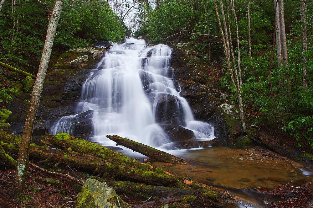
Here are but six of the hundreds of named and unnamed waterfalls that tumble and twist through our Appalachian mountains. We hope you enjoy! See the state maps in this issue for location indicators.

Virginia — Crabtree Falls

By Joe Tennis

Crabtree Falls

Crabtree Falls. Photo by Joe Tennis

A mere six miles off the Blue Ridge Parkway, near Milepost 27 in Nelson County, Va., Crabtree Falls makes a dramatic drop of more than 1,000 feet in the George Washington National Forest—just enough elevation to claim that Crabtree could be the highest cascading waterfall east of the Mississippi River.

Getting to the top requires a bit of a workout: the trail runs more than two miles on a steady climb, stopping along the way at overlooks, giving a look at not only Crabtree’s first major cascades, but also the dreamy landscape of the Tye River Valley.

For those less inclined to the strenuous hike, you can find the lowest falls on a universally accessible, paved trail with an overlook just a few hundred feet from the upper parking lot. The trail then turns to dirt, rocks and wooden steps as it makes its way higher.

In the 1970s, Crabtree made its way into pop culture. It was mentioned as a destination several times on “The Waltons,” a CBS-TV series based on the early life of Nelson County resident Earl Hamner, Jr.

From the Blue Ridge Parkway, travel to milepost 27 and exit onto Va. 56. Head east for about 6.3 miles to the national forest parking lot at 11581 Crabtree Falls Hwy., Montebello, Va. For more information, call Nelson County Tourism at (800) 282-8223 or visit www.nelsoncounty.com.

West Virginia — Peach Tree Falls

By Benji Burrell

Peach Tree Falls

Peach Tree Falls. Photo by Jaime Pettry

Right at the spot where Peach Tree Creek empties into the Marsh Fork River, there is—for adventurous explorers—a 30-foot waterfall waiting to be discovered.

Humming alongside the town of Naoma, W.Va., Peach Tree Creek offers a series of waterfalls and deep pools to play in the river. Downstream from the 30-foot fall, you will find a second set of falls with neat ledges and smaller channels of water where you can float around and bathe in the sun. The smaller ledges are accompanied by a rope swing, which awaits the more daring waterbugs.

Located in the heart of the coalfields, Peach Tree Falls, in all its modesty, is a cool spot in the middle of a place that has not been explored much by people outside of the local area. Peach Tree Falls is living proof that beauty exists even among a seemingly broken landscape.

From Glen Daniel, follow WV Route 3 twelve miles to Dry Creek. About 0.6 miles beyond, turn left, crossing the Marsh Fork River, then turn right. Follow the fork for about a mile to a parking area and trailhead.

To get to the second set of falls, rather than turning that last left, continue 1.6 miles into town. Once you pass through town, turn left on Peach Tree Road and park immediately on the right, walk down the river from there.

Kentucky — Princess Falls

By Jamie Goodman

Princess Falls

Princess Falls. Photo by Barb Richardson

The gentle, sheet-like drop of Princess Falls is nestled in the southern wilds of Daniel Boone National Forest.

Located 3.35 miles in on Lick Creek Trail, the breathtaking 17-foot high falls span a nearly-sheer wall almost 45 feet long and is named for Princess Cornblossom, leader of the Chickamaugan Cherokee tribe in the early 1800s.

The long ledge overhang continues around to the right of the falls (not pictured). Walking around the pool under the ledge puts you fairly close to the underside of the falls.

The trail, which follows Lick Creek, is considered intermediate, with multiple creek crossings, so be prepared for the possibility of getting your feet wet. To get there, take KY 478 west from Whitley City to KY 1651. Turn left (south) and follow 1651 for one mile before reaching Forest Development Road 662 on the right. The trailhead is 100 feet on the left at the gate. The trail follows an old roadbed along the ridge for a mile before changing to a footpath marked with white diamonds.

For the ultimate waterfall enthusiast, a whole series of stunning and out-of-the-way drops reside within the Daniel Boone National Forest, some bearing unique names such as Van Hook, Dog Slaughter and Bark Camp Cascades—including one, Kellacey Falls, that is accessible only by boat. Visit www.fs.fed.us/r8/boone/resources/water for a complete listing.

Tennessee — Fall Creek Falls

By Julie Johnson

Fall Creek Falls

Fall Creek Falls. Photo by Rich Stevens, ncwaterfalls.com

Just west of Pikeville, Tenn., in the 20,000 acre expanse of Fall Creek Falls State Park, Fall Creek snakes across the Cumberland Plateau and plunges 256 feet into a horseshoe-shaped pool. Viewing the falls from the overlook trail, you will see the highest free-fall waterfall east of the Mississippi River.

If you’re feeling more adventurous, hike the Gorge Trail along the Cane Creek River for views of four more incredible falls. First, Cane Creek Cascades tumbles down 45 feet, followed by the 85 foot drop at Cane Creek Falls. Just beside that falls, Rockhouse Creek rushes over a 125-foot drop into the same pool.

When the Gorge Trail comes to the confluence of the Cane Creek and Piney Creek Rivers, take an adjoining trail a mile or so up Piney Creek to view 95-foot high Piney Falls. Follow the trail from the base of the falls to a breathtaking overlook at the top of the falls.

At the Park’s Nature Center you can find information on the Rumbling Room, the second largest cave chamber in the U.S. Unfortunately, the cave is currently off limits due to white-nose bat syndrome.

To explore Fall Creek Falls State Park, take Interstate 40 west to exit 322. Take a left off the exit, and follow Highway 101 south for about 30 minutes. At the dead end, take a left to stay on 101. Go four miles and turn right on highway 30 west. Follow 30 for 5 miles and make a left into the park.

North Carolina — Tom’s Creek Falls

By Meg Holden

Tom's Creek Falls

Tom's Creek Falls. Photo by Rich Stevens, ncwaterfalls.com

Toms Creek Falls is well-known to McDowell County residents, but virtually unheard-of by most visitors to the area. Fortunately, the falls can be easily found and enjoyed by those unfamiliar with the region. These stunning falls are among many in the Pisgah National Forest, which covers over 500,000 acres in western North Carolina. Pisgah National Forest includes attractions such as the Cradle of Forestry, Mount Mitchell and the Linville Gorge Wilderness.

A fairly easy, half-mile hike leads to Toms Creek Falls, though a few steep slopes may be problematic for small children or those with difficulty walking. Moss-covered boulders near the trail provide ample resting, or climbing, spots. The trail comes out at the base of the 60-foot falls. The falls are vertical, multi-tiered and end in a wide, flat pool, perfect for wading. An old mica mine downstream from the falls has been flooded and abandoned. To get to the mine, cross the creek below the falls and follow the path to your left. The mine entrance, a rough tunnel filled with deep water, is on the right. Take some time to look for your own mica, but the mine is dangerous and should not be entered.

To reach the falls from Marion, head north on US-221, then turn left on Huskins Branch Road. A parking area is on the right about a mile down the road, just before the Toms Creek crossing. Visit NorthCarolinaWaterfalls.info to learn more info.

Georgia — Gorge Falls

By Jamie Goodman

Tallulah Gorge Falls

Tallulah Gorge Falls. Photo by Cindy Montgomery

If one waterfall a day just isn’t enough for you, the spectacular, 600-to 1,000-foot deep Tallulah Gorge in northeastern Georgia houses six separate waterfalls with a vertical drop of over 500 feet in less than a mile. The tallest is the gushing Hurricane Falls at 96 feet. Other falls in the drop include Tempesta (76 feet), the Oceana (50 feet), the l’Eau d’Or, pictured, (prounounced Lador, 46 feet), the sliding rock at Bridal Veil (17 feet) and Lovers Leap (16 feet).

The beauty of Tallulah Gorge has drawn visitors since the early 1800s. In 1913, Georgia Power built a hydroelectric dam at the mouth of the gorge to run Atlanta’s streetcars. The main section of the gorge—with its six spectacular waterfalls—was spared; however, the company diverted the water far downstream from the falls. As much as 10 times the amount of water ran through the gorge before 1913 as does today.

The 3-mile rim trail and a trail along the gorge floor provide alternate views of the falls, and scheduled releases from Tallulah Falls Lake in early April and November lure whitewater enthusiasts and people eager to see the falls in their original glory.

Located right off of U.S. 23/441, Tallulah Falls State Park (co-operated by the Georgia park system and Georgia Power) features camping, hiking, mountain biking, fishing, swimming and picnicking. Visit gastateparks.org/TallulahGorge for more information.

PA / Ohio — Cedar Falls

By Jared Shultz

Cedar Falls

Cedar Falls. Photo by Thomas Ramsey

Cedar Falls, located in the remote valley of Queer Creek in southeastern Ohio’s Hocking Hills State Park, is a great example of how man has worked with nature in both antiquated and modern ways.

In the mid-1800s, Cedar Falls was the site of a grist mill that ground grain with the help of water power. Now that the falls are an attraction for modern hikers and outdoor enthusiasts, they are home to an integrated staircase known as Democracy Steps. Born from the mind of artist, architect and mathematician Akio Hizume, the 100 steps were deliberately designed to evoke feelings of calm and relaxation in the visitor. The ecology of the falls features snapping turtles and stands of hemlock once mistaken by early white settlers for cedars, hence the name.

The state first purchased the land for the park in 1924 in order to preserve its many natural features, including Old Man’s Cave, Ash Cave, Rock House and Cantwell Cliffs. Once home to the Adena culture 7,000 years ago, and a passageway or temporary home for tribes like the Wyandot, Delaware, and Shawnee as recently as the mid 1700s, the park now acts as a sanctuary for residents of the region.

From Columbus, get on OH-664 S, follow for 53 miles and the highway will lead you directly into the park. Hiking to Cedar Falls itself takes just a half a mile from the parking lot. See hockinghills.com for more details.

Hidden Treasures-West Virginia

Monday, June 13th, 2011 - posted by Meg

A ruggedly beautiful landscape makes the Mountain State a huge draw for outdoor enthusiasts, but environmentally destructive mining practices pose a growing threat to attracting eco-tourism.

Mountaintop Removal Threatens Outdoor Mecca

By Jesse Wood

Rafting the New River. Photo courtesy of River Expeditions.

Rafting the New River. Photo courtesy of River Expeditions.

Once a booming coal town in southern West Virginia, Fayetteville thrives today because of the outdoor recreation and tourism industry. Yet mountaintop removal threatens the town as coal once again creeps closer to Fayetteville.

“As coal mining waned, tourism picked up the slack and boosted the economy,” said Mark Lewis, executive director of West Virginia Professional River Outfitters. “Most of the places in southern West Virginia where mining occurred didn’t have that. They didn’t have the New River Gorge to fill the void.”

In 1968, the late Joe Dragan started West Virginia’s first commercial rafting business along the New River. His vision of the area for outdoor recreation resulted in the New River Gorge becoming part of the National Park System (NPS) in 1978. Ten years later, the NPS established the Gauley National River Recreation Area.

“We have the New River and the Gauley, two of the best rafting and kayaking rivers in the country, and they are only about 15 miles apart,” Lewis said.

Last year, commercial rafting outfitters guided 140,000 people down the New and the Gauley.

“A lot of the commercial activity is due to the rafting industry, [but] private kayakers, as well as the climbers, make up a significant part of the economy,” Lewis said.

Climbing didn’t prosper in the New River Gorge as early as whitewater did, but the area, with 1,600-plus rope routes, draws thousands of climbers throughout the world each year.

The shift to an economy based on outdoor recreation and tourism altered the town’s demographic and culture. Lewis described Fayetteville as a sleepy town in the ‘80s, where most of the activity revolved around the courthouse.

Forest Management Falls Short

By Jillian Randel

A timber management project introduced in the Monongahela National forest doesn’t come without controversy. The Upper Greenbrier North Project will include timber harvesting and regeneration projects, and has citizens complaining about possible risks to the environment. The project fails to address a number of threatening concerns. Regeneration efforts include fencing off certain areas to keep out deer, while failing to address the greater problem of deer overpopulation; extensive use of herbicides that are not favored for heavy applications; and stream restoration plans that fail to address riparian systems as a whole. The project also fails to address the endangered northern squirrel population that relies heavily on the Monongahela Forest to repopulate. Visit: Greenbriar North Project Comments to comment.

“There weren’t near the number of restaurants or little businesses in town,” said Lewis. “It’s very different than most towns you’ll find in southern West Virginia because of the whitewater and climbing. This is a unique little eclectic community. It really transformed the town.”

In 2006, Outside magazine named Fayetteville a top-ten destination in the country for its paddling, climbing, biking and trail running.

But that isn’t the only top-ten list the area made. In 2010, American Rivers, a conservation organization, named the Gauley among America’s Most Endangered Rivers because of the devastating effects of mountaintop removal.

As mountaintop removal creeps closer towards Fayetteville, the town, and in turn the economy, may be ruined.

“People of Fayette County are really concerned,” said Stephanie Tyree, organizer for Ohio Valley Environmental Coalition (OVEC). “It’s one of the few areas in the state where tourism has really taken off. You see our state propaganda, ‘Wild and Wonderful,’ yet, just in the backroom, they are blowing up the mountains.”

Unfortunately, the backroom is only 3 ½ miles from town. In the past, surface mining took place on the edges of Fayette County.

“[This] is the first time surface mining has been right in the center of the county,” Tyree said. “It basically surrounds Fayetteville and the New River and is creeping closer.”

Frasure Creek Mining, a subsidiary of Trinity Coal, which is owned by the Indian conglomerate Essar Group, has three active surface mining permits, with six more pending or under review, near Fayetteville.

“[This is] the number one recreation destination in West Virginia,” said Vivian Stockman, project coordinator for OVEC. “And now we have an Indian company buying up all these mountaintop removal permits and with them, they are going to blast away this beautiful tourist hotspot.”


New River Gorge: World Class Climbing

The New River Gorge offers some of the best sandstone climbing in the country. The area, known around the world for its 1,600-plus rope climbs, has limitless bouldering and hundreds of deep water solo routes on the cliffs above Summersville Lake.

The 70,000 acre New River Gorge is so vast and relatively new, compared to other U.S. parks, that there is still much unclimbed territory.

One popular climbing “spot” is The Endless Wall, aptly named because it is 4 miles long. Many of the Endless Wall cliffs range from 80 to 140 feet tall. First ascents abound.


Dolly Sods: Heaven vs. Hydrofracking

By Frank Salzano

If you’ve never been to eastern West Virginia, you might wonder why the Mountain State is nicknamed “Almost Heaven.” If you have been, you’ve probably wondered why anyone ever included “almost” in the phrase.

The highlands country of West Virginia is part of the Allegheny Mountains that run north into Maryland and Pennsylvania. The name Allegheny comes from a Lenape Delaware word for the mythical peoples who first inhabited the area thousands of years ago.

This highlands region falls into the Monongahela National Forest (the “Mon”), which makes up the heart of the central Appalachians. Like the Blue Ridge of southern Appalachia, they construct the Eastern Continental Divide, creating an especially rich, lush ecosystem to the west of the high elevation ridges. The frigid spruce-fir forests of the far north, the north woods of New England and the extremely diverse mixed-mesophytic (moist) hardwoods of Appalachia all meet here.

Flowers bloom at Dolly Sods. Photo by Jaime Pettry.

Flowers bloom at Dolly Sods. Photo by Jaime Pettry.

The northern part of the Monongahela is home to the Dolly Sods Wilderness. The wilderness area is composed of a high elevation plateau that makes up part of the continental divide, and is the highest plateau of its type east of the Mississippi. It includes an area of 10,215 acres of wilderness for backpackers to explore. Covered with extensive rocky plains, upland bogs and sweeping vistas, it is the most popular wilderness area in the state.

The area’s unique microclimate is extremely cold and thus the plants and animals there are similar to ones found about 1,600 miles farther north. Dolly Sods is adjacent to other natural treasures like the Canaan Valley National Wildlife Refuge, which hosts some of the best cross-country skiing on the east coast, and the Seneca Rocks-Spruce Knob National Recreation Area, home to world-renowned rock climbing.

This area, like all of the Allegheny highlands country, is filled with small farms, tourism and a strong sense of Appalachian old-time culture—but it is currently under threat. Located over the Marcellus shale seam that contains natural gas, Dolly Sods is near several permitted sites to drill for natural gas using hydraulic fracturing methods, or hydro-fracking—a technique of drilling that injects liquid slurry into drilling sites to break up shale rock formations and allow more natural gas to be released.

Although the industry lobbied against disclosing what the fluids contain, congressional and EPA reports have found that many of the chemicals in the slurry, such as benzene, are known carcinogens, endocrine disruptors and generally hazardous to human health. Studies have shown that the process can pollute local water supplies with heavy concentrations of volatile organic compounds and heavy metals, like arsenic, lead and copper, which also cause cancer, kidney failure and fertility problems.

West Virginia is known for its natural beauty and rugged mountains, but it is also known for its poverty and history of exploitation in the coalfields. The Allegheny highlands and plateau provide an alternative economy to yet another extractive industry. The Dolly Sods Wilderness area is a unique place, as is the rest of the Mountain State. Protecting these mountains from destruction and using them for positive economic development will help ensure their future.


Wheeling: Eat, Shop, Play & Work in the Friendly City

Downtown Wheeling, W.Va., and the Ohio River from Wheeling Island. Photo by Tim Kiser.

Downtown Wheeling, W.Va., and the Ohio River from Wheeling Island. Photo by Tim Kiser.


By Meg Holden

Wheeling, located in the northern panhandle of West Virginia, has a rich and diverse history. Founded in 1769, trade along the Ohio River and the National Road transformed this frontier town into “the gateway to the West” by the mid-nineteenth century. The Wheeling Convention established West Virginia’s independence from Virginia in 1863. Iron and steel mills on the banks of the Ohio River helped Wheeling become a center of industry by the late 1800s.

Today, Wheeling is known as the “Friendly City.” Civic groups in Wheeling work to preserve the city’s cultural heritage. Historic sites such as the West Virginia Independence Hall, the Victoria Theater and the La Belle Cut Nail Plant represent different aspects of Wheeling’s history. The annual Italian Festival, Jamboree in the Hills, Wheeling Nailers hockey club games and Ogden Newspaper Distance Race Classic are just a few events that attract visitors to the area.

Orchids: The Grace, Strength and Beauty of the Mountains

Monday, June 13th, 2011 - posted by Meg

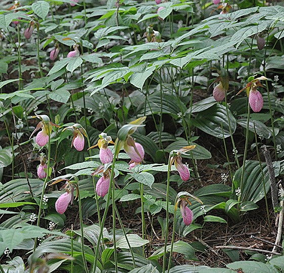
By Julie Johnson

The beauty and mystique of Appalachia’s wild orchids have seduced many a woodland explorer. Like the flowers’ curious pollinating insects, these brilliant and prolific plants keep us coming back for more.

Orchids are a fascinating study in plant intelligence and ecological symbiosis. To ensure the continued existence of their species, orchids, through millions of years of trial and error, have developed intricate adaptations designed to lure their favored insect into carrying their pollen from plant to plant.

Once an orchid has successfully nabbed a pollinator, the survival of its germinated seed relies on another forest neighbor: fungus. Fungi fibers stretch out to the needy seed and give it the carbon it needs to flourish and begin the cycle again.

In Appalachia, over 50 known native species of orchids live in forests, meadows and rock faces. Take it slow on your next mountain excursion, and see if you can spot the glorious orchid at work. Remember, these plants rely on intricate systems for survival, so attempting to pick or transplant them will kill them, and further threaten already endangered plant species.

Spring Bloomers

Yellow Lady Slipper (Cypripedium calceolus)
Flowers April – June

This orchid bears a splendid yellow bulb under its wispy wine-colored petals. The Cherokee called it “Yellow Moccasin” and reportedly used an infusion of its roots to treat children infected with worms, and as an analgesic.

Pink Lady's Slipper

Pink Lady's Slipper


Pink Lady Slipper (Cypripedium acaule)
Flowers May – July

Like its cousin Yellow Moccasin, the Pink Lady Slipper is pollinated by luring bumblebees into its pouch. Once trapped, the bee can only exit through a complex reproductive maze. First it must pass beneath the stigma, which rubs off any pollen the bee may be carrying from a previous plant visit, then it works its way toward the exit, just past the plants pollen mass, which it carries on naively to the next plant.

Summer Bloomers

Downy Rattlesnake Plantain

Downy Rattlesnake Plantain


Downy Rattlesnake Plantain (Goodyera pubescens)
Flowers July – August

Rattlesnake Plantain is so called because of the unique snake-skin pattern on its dark green leaves. A cluster of tiny white blooms open like hungry mouths on its tall stalk, waiting for its bee pollinators to take the bait. This orchid also loves acidic soil, and can often be found growing in hemlock stands. Some traditional remedies claim that a tea made from the roots will cure snakebites, and a tea made from the leaves will cure rheumatism and toothaches.

Flowers Mid July – Late August

The Crane-fly is a noctodorous orchid, meaning that it only releases its fragrance at night. This attracts its favorite pollinator, the noctuidae moth, who receives the pollen on its eye from the slightly twisted column of the flower. During the winter the plant can be identified by a single leaf protruding from the forest floor, which is either dark purple or dark green, with purple spots.

Fall Bloomers

Yellow-Fringed Orchid

Yellow-Fringed Orchid


Yellow-Fringed (Platanthera ciliaris)
Flowers August – Late September

This flamboyant yellow-orange orchid is pollinated by butterflies and thrives in damp meadows and mountain slopes. Its small blooms feature a prominent lower petal rimmed with tiny fringe. They grow in a cluster at the top of a foot-long stem.


Tresses

Tresses


October Ladies’-Tresses (Spiranthes ovalis)
Flowers August – November

The Spiranthes genus has 300 known members of its family of delicate spiraling orchids. The flowers’ thin, 14-inch stalk shoots straight up out of the forest floor, ending in a tight spiral of small white blooms. It is a self-pollinator and prefers shady wooded areas.

The Crash Pad

Monday, June 13th, 2011 - posted by meghan

Bunkbeds Never Looked So Good


By Julie Johnson

Hosteleers, your green dream is about to arrive. This June, The Crash Pad, the country’s first LEED certified hostel, will open in Chattanooga, Tenn. Forget the usual rickety bunk beds with questionable linens, crammed five or six to a room. The Crash Pad is a green-minded traveler’s dream hostel.

When Dan Rose and business partner Max Poppel bought an acre of land in Chattanooga’s Southside district, it was a trashed lot with two condemned houses. Rose and Poppel, both avid climbers, saw the potential for a hostel that catered to folks coming for the numerous outdoor adventuring opportunities in the Chattanooga area.

The outside of the new Chattanooga hostel, the Crash Pad

The outside of the new Chattanooga hostel, the Crash Pad


“We want to help further establish Chattanooga as an ultimate outdoor destination,” said Rose. “This sustainably built and operated establishment will provide a base camp and community hub for adventurous travelers.”

The Crash Pad features sleek bunks crafted by Chattanooga’s Haskel Sears Design. A bed in one of the bunks is $27 per night and there are only two bunk beds per room. Each of the four beds sports a privacy curtain, reading light, personal fan and electrical outlet. Private rooms feature a queen bed, constructed of reclaimed lumber, and an in-room sink and run $70 per night.

“We salvaged all the lumber after demolishing the old houses on the property, gave it to Matt Sears, and he used it to create all the beds in the hostel,” said Rose.

Forget the watery coffee and stale bagel tray. “We’re collaborating with our neighbor Niedlov’s, a family-owned organic bakery just down the street,” said Poppel. “Fresh breakfast is included in your cost and coffee from a local roaster is available for free all day.”

The kitchen common area features a recycling center and a custom concrete island inlaid with old climbing and biking gear made by Chattanooga artisans Set in Stone. The company also made sinks for the bathrooms crafted from glass salvaged from broken bottles that littered the property. Each bathroom has a low-flow toilet and shower.

“We decided to construct the building itself out of precast concrete because it’s ideal for both energy efficiency and quiet,” said Poppel.

A green screen on one side of the building will allow vines to crawl up the exterior walls, providing more plant-powered insulation. The roof is a living one, covered with native plants that help absorb sunlight and naturally cool the interior in summer. Natural lighting is used as much as possible and is minimally supplemented by LED and compact fluorescent bulbs

“Though it’s right in the heart of downtown, we’ve managed to provide a full acre of green space,” said Rose.

You can hammock, slack line and picnic to your heart’s content on small hills that have been built up of dirt excavated from the property and sown with native plants and grasses. An outdoor pavilion, made of salvaged bricks and lumber, and wired for light, heat and sound, stands on the foundation of one of the demolished houses.

“We’ve got a huge database of information on outdoor activities,” said Rose. Chattanooga sits in the lush Tennessee River Valley, just between the Appalachian Mountains to the east and the Cumberland Plateau to the west, and is quickly becoming established nationally as a prime location for whitewater boating, climbing, hiking and biking.

When Rose and Poppel decided they wanted the Crash Pad to be as green as possible, they contacted Green Spaces, a non-profit organization that provides incentive funding for area businesses to build sustainably. Green Spaces paid for their LEED certification and part of their living roof.

“We have to give them major credit, as well as all the incredible local craftspeople and builders that made the place come to life,” said Rose.

The Crash Pad will celebrate its grand opening with a ribbon cutting on Friday, June 3. The hostel will officially open for business on June 8th. Visit crashpadchattanooga.com to book reservations.

Inside Appalachian Voices

Monday, June 13th, 2011 - posted by meghan

“The Last Mountain” Makes its First Appearance Nationwide

Robert F. Kennedy, Jr. and Bill Raney debate mountaintop removal in the film, The Last Mountain, by Uncommon Productions

Robert F. Kennedy, Jr. and Bill Raney debate mountaintop removal in the film, The Last Mountain, by Uncommon Productions

By Rachael Goss

Film director Bill Haney recognized the highly visual and personal nature of mountaintop removal on communities and the environment. This summer Appalachian Voices will hit the road with his documentary, “The Last Mountain,” exposing the issue to new audiences across America.

A Sundance Official Selection, “The Last Mountain” is described as “… a passionate and personal tale that honors the extraordinary power of ordinary Americans when they fight for what they believe in.”

The film chronicles the impact that mining practices have on the Coal River Valley in West Virginia, and includes powerful interviews with local residents whose lives and livelihoods have been affected by mountaintop removal.

Haney said he was moved by “the heroic quality of the people of Appalachia … I met these people who are so inspiring and want to protect their heritage and use their right to the democratic process.”

“The fact is that 2/3 of the folks in Coal River don’t want mountaintop removal, but all of their politicians do,” said Haney. “This is not democracy and these people are fighting to see it. They are fighting to maintain their cultural heritage and the land they rely on—these glorious beautiful mountains.”

Appalachian Voices’ staff, representing iLoveMountains.org and the Alliance for Appalachia, will be present at screenings in eleven cities across the nation this summer. Please support the fight to end mountaintop removal by attending a showing at a theater near you; for more information on theaters and show times, visit thelastmountainmovie.com.

Coming to the following Cities in June:

New York City
Washington, D.C.
Nashville
Los Angeles
Irvine
Philadelphia
San Francisco
Berkeley
Boston
Chicago
Pittsburg
Charlotte
Knoxville
Portland
Austin

Appalachian Water Watch Full Speed Ahead

By Jillian Randel
Appalachian Water Watch is moving forward in their Clean Water Act lawsuit against Kentucky coal company Nally & Hamilton. On May 10, Appalachian Voices, Kentuckians for the Commonwealth, Kentucky Riverkeeper and Waterkeeper Alliance filed suit in federal court against the coal company for 12,000 violations of the Clean Water Act.

The violations occurred at more than a dozen of Nally & Hamilton’s operations in Kentucky, with evidence indicating that they filed false and potentially fraudulent water pollution monitoring data with state agencies over the past three years.

On the 59th day of the 60-day filing period, the Commonwealth of Kentucky filed an administrative complaint citing Nally & Hamilton with 4,630 violations of the Clean Water Act and making an initial assessment of $25,000 per violation for a maximum penalty of $115 million.

Feeling that the $115 million dollar fine would likely get cut throughout the proceedings, Appalachian Voices filed a separate Citizens Clean Water Act suit in federal court against the company to ensure the penalties are enough to prevent more violations from happening in the future.

In October 2010, Appalachian Voices and partners filed a legal action against two other mountaintop removal coal mining companies in Kentucky—ICG and Frasure Creek.

Appalachian Voices’ Water Watch team found more than 20,000 violations of the Clean Water Act in water reports filed by the two companies, with maximum potential fines of $740 million. The companies exceeded pollution discharge limits in their permits and in many cases submitted false monitoring data.

Appalachian Water Watch is preparing for the trial against ICG and Frasure Creek. Mediation will take place on June 8, and the trial will likely occur in August. To keep up to date, visit: appvoices.org/waterwatch/ky-legal-action/

Starting Summer With a Splash

As we go to press, the tents are going up and the smell of smoking barbecue is filling picturesque Valle Crucis, N.C., in preparation for Appalachian Voices’ 2nd annual RiverFest on Saturday, June 4.

In case you weren’t able to make it (and we hope you did!), we hosted a full afternoon of fun and games all focused around a central theme—teaching our neighbors about the conservation of our mountain rivers.

Stations included a water cycle obstacle course for kids (where kids then “became” water droplets and learned how water travels from clouds to our kitchen sink!), a pickin’ parlor for the musically inclined, a no-hands watermelon eating contest, fly tying and casting clinics, and a chance to meet a live hellbender salamander!

The event also served as our annual membership meeting, where we gathered with staff and members to talk about the coming year of Appalachian Voices and our work to protect the air, land, water and communities of Appalachia.

Visit AppalachianVoices.org/Riverfest to learn more about the event and see photos after the fact—hopefully you’ll be in some of them!

No Charge for Discharge

On Wednesday April 20, 2011, Assistant Waterkeeper Eric Chance noticed that Laurel Fork River, in Boone, N.C, was running a grayish color. After tracking down the source of the gray water, it turned out to be discharge from the Vulcan Boone Quarry. The Vulcan Boone Quarry has had previous issues with discharging milky white and gray water. As a result, they installed a camera to monitor their discharge. Although the state was notified and issued a monitoring checklist for Vulcan Quarry to follow, they have indicated that no fines will be issued for the violation. – By Jillian Randel

Operation Medicine Cabinet a Success

The High Country’s Spring 2011 Operation Medicine Cabinet took 87,285 pills and 17 liters of liquid medication off the streets, keeping them out of the hands of children and out of our rivers. Over 170 citizens participated at grocery stores and other drop-off locations in Boone, Blowing Rock, Deep Gap and Seven Devils. – By Meg Holden

You Helped Us Reach Our Goal!

Thanks to the generous support of our members, we were able to raise $32,000 in our Earth Day Water Watch Matching Gift Challenge! The funds will go to our Appalachian Water Watch team to help us pay for legal experts in a case against two coal companies for violations of the Clean Water Act. For more information about these cases (and the team’s third lawsuit) see the story on this page. – By Parker Stevens

Electric Utility Discusses Clean Energy

One of the country’s largest electric utilities, Dominion Resources, voted on a shareholders resolution to consider phasing out purchasing coal extracted by mountaintop removal, among other clean energy resolutions. The resolution received 9% of shareholder votes. While this isn’t close to passing we hope it will help the board take notice of the importance of clean energy initiatives. — By Mike McCoy

Mercury: It’s Not Just in the Fish

Everyone knows that mercury can cause severe birth defects if a mother-to-be ingests too much of it from fish, but not everyone knows where the mercury in fish comes from. One source: coal-fired power plants. Appalachian Voices worked alongside the Sierra Club to test 40 Hampton Roads, Va., citizens’ mercury levels. Hampton Roads waterways are inundated with mercury fallout from several nearby coal plants. Still, the largest coal-fired power plant in the state is being proposed, and would be located just upwind of the Hampton Roads Region. Residents still await test results. Check back with wiseenergyforvirginia.org/ – By Mike McCoy

Hidden Treasures – Virginia

Wednesday, June 8th, 2011 - posted by Meg

400 hundred years of U.S. history and an eternity of natural wonders run from the Appalachian Mountain Ridges to the Shenandoah Valley and on to a coast that is one of the south’s finest.

Playing to the crowd at the 2010 FloydFest. Photo by Russ Helgren.

Playing to the crowd at the 2010 FloydFest. Photo by Russ Helgren.

Music Tourism Gives Floyd Economy a Boost

By Bill Kovarik and Jason Coleman

If there is a poster child for music, art and recreational tourism in Appalachia, it would have to be Floyd, Virginia.
For most of the 20th century, Floyd County was just another sleepy farming community along the Blue Ridge Parkway, known for little more than high-octane moonshine.

But over the past two or three decades, as retirees and other refugees from urban life settled here, a thriving music, arts and crafts scene came together in a dozen different venues.

Mining the Beauty out of the Mountains

By Jillian Randel

Virginia, with all its natural wonders, is not immune to the same threats as neighboring states, West Virginia and Kentucky. Mountaintop removal practices plague the southwestern part of the state. A permit is currently pending for Ison Rock Ridge, a surface mine that, in addition to exacerbating health effects associated with current surface mining practices, would destroy three miles of streams and fill nine valleys with more than 11 million cubic yards of rock and dirt. Visit: samsva.org for more information.

Today you can find concerts, gallery openings, wine tastings, art classes, renewable energy workshops, poetry readings and local theater productions going on more or less constantly.

Floyd’s musical reputation goes back to the dawn of the bluegrass era. In the 1980s, local bluegrass bands began playing at the Floyd Country Store every Friday night. The store became a fixture of bluegrass culture and, recently, an important anchor for the “Crooked Trail” heritage music tourism route through southwestern Virginia.

Another major contributor to the music scene is Floyd Fest, celebrating its tenth anniversary this year. Kris Hodges and Erica Johnson, restaurant owners in Floyd, wanted to bring world-class entertainment to the New River Valley. What began in 2001 as a gathering of 1,500 like-minded rock and bluegrass lovers has grown to about 12,000 people enjoying entertainment from around the world.

“Our vision was to produce a world music festival for the entire family and that’s not just a catch phrase, we mean it,” said Linda DeVito, operations director for Across the Way Productions. “We pride ourselves in the fact that most of us have kids, we wanted to provide a festival where a patron, even us, would feel comfortable in bringing our kids to.”

Still other music venues include the Dogtown Roadhouse with concerts every weekend, the June Bug music education center and the National Music Festival, a classical music festival starting this May that, organizers hope, will be an annual event.

Floyd is also known as a Mecca for serious artists and crafts folk, and their anchor is the Jacksonville Center—an old barn near town that was converted ten years ago into an art studio with a gallery featuring pottery, textiles, painting and crafts shows.

According to Lydeana Martin, the county’s community and economic development director, music and arts tourism brings an estimated $18 million a year and at least 200 jobs to Floyd.

Efforts to take advantage of tourism and broaden the county’s economic base include an expanded farmers’ market and two new county task forces to address land policy and agriculture and forest economic viability.

Visit: floydvirginia.com


Douthat State Park

Douthat State Park, Photo by Jamie Goodman

Photo by Jamie Goodman


By Jamie Goodman

Tucked away in the Allegheny Mountains in western Virginia, Douthat provides a sturdy blend between moderately outdoorsy and activity-based family vacations. The 4,493-acre park offers 40 miles of wildlife-rich hiking/biking trails, a 50-acre lake with swimming and boating and a full-service restaurant. Those seeking more remote excursions can explore the surrounding George Washington National Forest, which boasts hundreds of miles of hiking trails and more than 30 campgrounds ranging from primitive to full-hookups. Visit: dcr.virginia.gov/state_parks/dou.shtml.


Small Farming Staying Alive through Diversification

By Bill Kovarik

Historically rich and classically pastoral, the Shenandoah Valley of Virginia is searching for sustainability through agricultural tourism.

On a Shenandoah farm just north of Lexington, Cyrus McCormick launched an industrial revolution in agriculture by inventing the first mechanical harvester in 1831.

A dozen miles away, in the shadow of the Appalachians, farmer-philosopher Joel Salatin launched a different kind of revolution on Polyface Farms. Sustainable agriculture, he hopes, “will see thousands and thousands of diversified farms serving their bioregional locavores.”

Although separated by 180 years of social change, McCormick and Salatin would feel more at home on each others farms than on the sprawling industrial poultry complexes that dominate the landscape further up the valley.

Many of Salatin’s farm neighbors feel the same way—they are not entirely happy with the sprawling suburban developments that threaten the pastoral vistas and the farming way of life. Nor has it been easy to compete with industrial scale farms that produce high quantities of food at the expense of quality and the environment.

The idea of rolling out a big green welcome mat for agri-tourists is, in large part, a hope that small and moderate sized farmers can supplement their income with a wide variety of activities that fall into the category of agri-tourism.

The activities range from farm-stay family vacations to wineries and horse farms that offer deluxe catering for weddings and special occasions. They also include the increasingly familiar activities like U-pick farms, corn mazes, tractor rides and pumpkin patches.

To become better known as a major agri-tourism destination, a group of county and regional planners, working with farmers, is launching a program called Fields of Gold. They hope it will be to agri-tourism what the Crooked Road of southwestern Virginia is to music. The state agriculture department recently approved planning funds for the first stage of the initiative, with every county in the central valley chipping in.

Anchoring the agri-tourism concept is the Frontier Culture Museum, a state-supported living history museum where farm life from Africa, Europe and early North America is re-enacted daily. Offering museum-like tours and summer camps for children, the museum recently faced drastic state funding cuts. The McCormick museum, half an hour south on I-81, also offers a link to the past.

Tourism is not new to the Shenandoah. The region has long been known for its caverns–Luray, Shenandoah, Grand, Skyline and Endless, among others.

The area is also gaining attention for the Shenandoah Valley Wine Trail and for dozens of other destinations that fall under the label of agri-tourism. The process of organizing and marketing animates the Fields of Gold initiative.

“This area has a rich history and culture that surrounds land based economies,” said Monica Plecker, a planning assistant with the Central Shenandoah Planning Commission. “There is an identity, a sense of rural living, that some feel is dwindling. The initiative will brand the region as agri-tourism destination with a variety of options.”


Grayson Highlands State Park

By Meg Holden

A wild pony of Grayson Highlands. Photo by Katie Boyette

A wild pont of Grayson Highlands, Photo by Katie Boyette


Stunning views, unusual geologic formations and wild ponies—Grayson Highlands State Park in the Jefferson National Forest has all these and more. Located on US 58 between Independence and Damascus, Va., Grayson Highlands attracts hikers, campers and equestrians from all over the U.S.
The state park is home to forests, as well as balds, high-altitude meadows with rocky outcroppings and low vegetation. Balds such as the ones in Grayson Highlands threatened to disappear in the early twentieth century, when state and national parks prohibited large-scale livestock grazing. Surrounding forests began reclaiming the exposed grassy and heath balds until maintenance measures were enacted.
The Grayson Highlands balds are maintained by a herd of introduced wild ponies. These ponies are accustomed to visitors and will not shy away from humans, but should not be petted or fed.
Camping, horseback riding, fishing and hiking are permitted in Grayson Highlands. A fall festival is held every year and includes live music, demonstrations of pioneer life, a craft sale and an auction for excess colts from the pony herd. More information is available at dcr.virginia.gov/state_parks/gra.shtml.

Environmental News from Around the Region

Wednesday, June 1st, 2011 - posted by Meg

Shady Valley Residents Speaking out on Pesticide Use

By Meg Holden

Shady Valley, Tennessee is small, rural and quiet—quiet until now, that is. The recently formed organization Shady Valley Neighbors for Clean Air and Water is speaking out against environmental injustice in their community, and it isn’t so quiet in the valley now.

B&W Quality Growers rented land in the Shady Valley area to grow arugula and other greens, but recent events have community members wondering about B&W’s growing practices. The Shady Valley Neighbors for Clean Air and Water believe that the wells drilled by B&W for irrigation may have lowered the water table in the valley, causing sinkholes along US 421.

Residents are also concerned about the impact of B&W’s use of metam sodium, a pesticide listed by the U.S. Environmental Protection Agency as highly toxic and a likely carcinogen. Shady Valley Neighbors for Clean Air and Water president Tony Barry stated in a press release that between 30 and 50 people, including children, were exposed to metam sodium fumes after an application of the chemical to Shady Valley fields by Highland Soil Fumigation Company on behalf of B&W. Shortly after the application, residents reported respiratory problems, headaches, nausea, severe coughing and blisters.

Both B&W and Highland Soil Fumigation Company have been fined by the Tennessee Department of Agriculture and the EPA is currently investigating the metam sodium misapplication. The Tennessee Forestry Commission visited the area and warned the growers to control their application of metam sodium.

The Shady Valley Neighbors for Clean Air and Water will continue to monitor the water table and B&W’s arugula fields and growing practices and hope to prevent further unsafe practices.

Nuclear Dumpsite threatens Asheville Residents … for the second time

By Meg Holden

In 1988, a North Carolina Geological Survey determined that Sandy Mush, less than 30 minutes from Asheville, would be an unsuitable dumpsite for nuclear waste. Now, the Federal Blue Ribbon Commission on America’s Nuclear Future is again considering western North Carolina as a location for a permanent disposal site.
As the campaign for alternative energy continues, nuclear power is frequently considered an option to replace coal and petroleum. The persistent problem with nuclear power is its by-product—the highly radioactive waste that must be contained indefinitely.

A group of concerned residents have created a coalition called The Mountain Protectors to oppose the possibility of locating a dumpsite in western North Carolina. Parties interested in The Mountain Protectors can call 828-301-6683. More information on nuclear hazards in the southeast is available at nirs.org/southeast/sehome.htm

White-Nose Syndrome Spreads to North Carolina

By Tim W. Jackson

Insect-eating bats in the United States likely save the agricultural industry at least $3 billion a year, yet bats are often overlooked as economically important, non-domesticated animals in North America.

Affecting bats from New England through Virginia, the disease has now moved into North Carolina (confirmed in Avery and Yancey counties thus far).
“Bats are saving us big bucks by gobbling up insects that eat or damage our crops,” said Paul Cryan, a U.S. Geological Survey research scientist. “These bats deserve help.”

In March, the Western North Carolina Alliance in Asheville hosted a panel to discuss white-nose syndrome, how it affects bats and what we can do to help.
A disease believed to be caused by the fungus Geomyces destructans, white-nose syndrome is estimated to have killed more than a million bats in the eastern United States since 2006. White-nose syndrome was discovered five years ago, but as of now there is no treatment or cure.

Steps taken to monitor bat populations and inform the public about white-nose syndrome include: closing caves and mines, information sessions with the public on how to avoid and minimize the spread of the disease and the development of protocols for decontamination of equipment and clothing for researchers.

“If anyone notices unusual behavior from bats, like flying during the day, sick or dead bats, they should report these observations to the North Carolina Wildlife Resources Commission in their area,” said Susan Loeb, research ecologist for the U.S. Forest Service.

Panel experts expressed concern that the disease can kill up to 100 percent of bat colonies during hibernation and could lead to the extinction of numerous bat species.

To report abnormal bat behavior in your area contact the North Carolina Wildlife Resources Commission Office at 919-707-0050 or the U.S. Fish & Wildlife Service at 828–258–3939.

NC Greenlights 150 Turbine Wind Farm

North Carolina regulators have given the go-ahead for a 300-megawatt wind farm to be located on private farm lands in the eastern counties of Pasquotank and Perquimans near Elizabeth City, N.C. The wind farm will produce enough electricity to power between 55,000 and 100,000 homes. The Iberdrola Renewables Inc. wind farm will be the first of its kind in North Carolina as Duke Energy, which operates 1000-megawatts of wind energy production outside the state, has officially withdrawn its proposal for a three turbine/9-megawatt offshore wind farm.

Sewage Pollutes Tenn. Waterways

Local officials are still unable to determine the long-term environmental and economic effects of a Gatlinburg, Tenn., sewage spill in early April of this year. The spill killed two workers and dumped an estimated four million gallons of untreated sewage into the nearby Little Pigeon River—part of the Smoky Mountains National Park—after a holding tank wall collapsed on site at the Veolia Water North America plant. The Tennessee Department of Environment and Conservation is conducting extensive sampling of the river both upstream and down. Signs lining the river warn of elevated levels of fecal (sewage) bacteria and advise residents to avoid swimming or fishing. Long-term health effects are yet to be determined. Visit: health.state.tn.us.

River Value Gets a Boost

American Rivers was recently selected to oversee a $1.8 million dollar grant for projects aimed at improving the communities and rivers in the Potomac Highlands. The highlands cover areas in Penn., Va., Md. and W.Va. The grant will be divided among ten projects focused on rebuilding the ecological resources, services and value of the Potomac Highlands, which suffer from severe ecological damage. As part of the Mid-Atlantic Highlands Program, these projects are aimed at restoring areas of significant cultural and ecological importance. Visit: epa.gov/reg3esd1/highlands-plan.html.

Flying Back onto Endangered Species List

On March 25 of this year, the Northern flying squirrel was ruled back on the endangered species list by a federal court decision. The species relies on mature and old-growth forests in Appalachia such as the Monongahela National Forest of West Virginia. Logging, road building and oil and gas development contribute largely to the species’ dwindling numbers. In a 2008 decision, after the U.S. Fish and Wildlife service failed to address population decline, the squirrel was unceremoniously dropped from the endangered species list. The new ruling will go a long way to afford the squirrel, as well as its surrounding habitat, the protections it needs to recover. Visit: saveblackwater.org.

Blue Ridge Musicians Honored

On June 11, five outstanding artists will be inducted into the Blue Ridge Music Hall of Fame. This year’s Hall of Fame inductees are singer-songwriter Emmylou Harris, dancer Willard Watson, banjo player Jens Kruger, songwriter Jim Lauderdale and fiddler Jim Shumate. Located in Wilkesboro, N.C., the Blue Ridge Music Hall of Fame promotes and protects the musical heritage of the Blue Ridge Mountains. Exhibits and Hall of Fame inductions define and celebrate the musical history of the Blue Ridge, including regional music and musicians in all genres. Visit: blueridgemusichalloffame.com.