Here are but six of the hundreds of named and unnamed waterfalls that tumble and twist through our Appalachian mountains. We hope you enjoy! See the state maps in this issue for location indicators.
Virginia — Crabtree Falls
By Joe Tennis
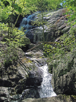
Crabtree Falls. Photo by Joe Tennis
A mere six miles off the Blue Ridge Parkway, near Milepost 27 in Nelson County, Va., Crabtree Falls makes a dramatic drop of more than 1,000 feet in the George Washington National Forest—just enough elevation to claim that Crabtree could be the highest cascading waterfall east of the Mississippi River.
Getting to the top requires a bit of a workout: the trail runs more than two miles on a steady climb, stopping along the way at overlooks, giving a look at not only Crabtree’s first major cascades, but also the dreamy landscape of the Tye River Valley.
For those less inclined to the strenuous hike, you can find the lowest falls on a universally accessible, paved trail with an overlook just a few hundred feet from the upper parking lot. The trail then turns to dirt, rocks and wooden steps as it makes its way higher.
In the 1970s, Crabtree made its way into pop culture. It was mentioned as a destination several times on “The Waltons,” a CBS-TV series based on the early life of Nelson County resident Earl Hamner, Jr.
From the Blue Ridge Parkway, travel to milepost 27 and exit onto Va. 56. Head east for about 6.3 miles to the national forest parking lot at 11581 Crabtree Falls Hwy., Montebello, Va. For more information, call Nelson County Tourism at (800) 282-8223 or visit www.nelsoncounty.com.
West Virginia — Peach Tree Falls
By Benji Burrell
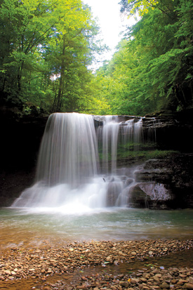
Peach Tree Falls. Photo by Jaime Pettry
Right at the spot where Peach Tree Creek empties into the Marsh Fork River, there is—for adventurous explorers—a 30-foot waterfall waiting to be discovered.
Humming alongside the town of Naoma, W.Va., Peach Tree Creek offers a series of waterfalls and deep pools to play in the river. Downstream from the 30-foot fall, you will find a second set of falls with neat ledges and smaller channels of water where you can float around and bathe in the sun. The smaller ledges are accompanied by a rope swing, which awaits the more daring waterbugs.
Located in the heart of the coalfields, Peach Tree Falls, in all its modesty, is a cool spot in the middle of a place that has not been explored much by people outside of the local area. Peach Tree Falls is living proof that beauty exists even among a seemingly broken landscape.
From Glen Daniel, follow WV Route 3 twelve miles to Dry Creek. About 0.6 miles beyond, turn left, crossing the Marsh Fork River, then turn right. Follow the fork for about a mile to a parking area and trailhead.
To get to the second set of falls, rather than turning that last left, continue 1.6 miles into town. Once you pass through town, turn left on Peach Tree Road and park immediately on the right, walk down the river from there.
Kentucky — Princess Falls
By Jamie Goodman
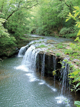
Princess Falls. Photo by Barb Richardson
The gentle, sheet-like drop of Princess Falls is nestled in the southern wilds of Daniel Boone National Forest.
Located 3.35 miles in on Lick Creek Trail, the breathtaking 17-foot high falls span a nearly-sheer wall almost 45 feet long and is named for Princess Cornblossom, leader of the Chickamaugan Cherokee tribe in the early 1800s.
The long ledge overhang continues around to the right of the falls (not pictured). Walking around the pool under the ledge puts you fairly close to the underside of the falls.
The trail, which follows Lick Creek, is considered intermediate, with multiple creek crossings, so be prepared for the possibility of getting your feet wet. To get there, take KY 478 west from Whitley City to KY 1651. Turn left (south) and follow 1651 for one mile before reaching Forest Development Road 662 on the right. The trailhead is 100 feet on the left at the gate. The trail follows an old roadbed along the ridge for a mile before changing to a footpath marked with white diamonds.
For the ultimate waterfall enthusiast, a whole series of stunning and out-of-the-way drops reside within the Daniel Boone National Forest, some bearing unique names such as Van Hook, Dog Slaughter and Bark Camp Cascades—including one, Kellacey Falls, that is accessible only by boat. Visit www.fs.fed.us/r8/boone/resources/water for a complete listing.
Tennessee — Fall Creek Falls
By Julie Johnson
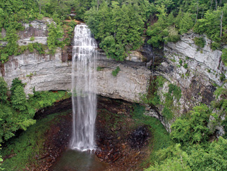
Fall Creek Falls. Photo by Rich Stevens, ncwaterfalls.com
Just west of Pikeville, Tenn., in the 20,000 acre expanse of Fall Creek Falls State Park, Fall Creek snakes across the Cumberland Plateau and plunges 256 feet into a horseshoe-shaped pool. Viewing the falls from the overlook trail, you will see the highest free-fall waterfall east of the Mississippi River.
If you’re feeling more adventurous, hike the Gorge Trail along the Cane Creek River for views of four more incredible falls. First, Cane Creek Cascades tumbles down 45 feet, followed by the 85 foot drop at Cane Creek Falls. Just beside that falls, Rockhouse Creek rushes over a 125-foot drop into the same pool.
When the Gorge Trail comes to the confluence of the Cane Creek and Piney Creek Rivers, take an adjoining trail a mile or so up Piney Creek to view 95-foot high Piney Falls. Follow the trail from the base of the falls to a breathtaking overlook at the top of the falls.
At the Park’s Nature Center you can find information on the Rumbling Room, the second largest cave chamber in the U.S. Unfortunately, the cave is currently off limits due to white-nose bat syndrome.
To explore Fall Creek Falls State Park, take Interstate 40 west to exit 322. Take a left off the exit, and follow Highway 101 south for about 30 minutes. At the dead end, take a left to stay on 101. Go four miles and turn right on highway 30 west. Follow 30 for 5 miles and make a left into the park.
North Carolina — Tom’s Creek Falls
By Meg Holden
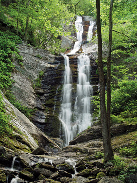
Tom's Creek Falls. Photo by Rich Stevens, ncwaterfalls.com
Toms Creek Falls is well-known to McDowell County residents, but virtually unheard-of by most visitors to the area. Fortunately, the falls can be easily found and enjoyed by those unfamiliar with the region. These stunning falls are among many in the Pisgah National Forest, which covers over 500,000 acres in western North Carolina. Pisgah National Forest includes attractions such as the Cradle of Forestry, Mount Mitchell and the Linville Gorge Wilderness.
A fairly easy, half-mile hike leads to Toms Creek Falls, though a few steep slopes may be problematic for small children or those with difficulty walking. Moss-covered boulders near the trail provide ample resting, or climbing, spots. The trail comes out at the base of the 60-foot falls. The falls are vertical, multi-tiered and end in a wide, flat pool, perfect for wading. An old mica mine downstream from the falls has been flooded and abandoned. To get to the mine, cross the creek below the falls and follow the path to your left. The mine entrance, a rough tunnel filled with deep water, is on the right. Take some time to look for your own mica, but the mine is dangerous and should not be entered.
To reach the falls from Marion, head north on US-221, then turn left on Huskins Branch Road. A parking area is on the right about a mile down the road, just before the Toms Creek crossing. Visit NorthCarolinaWaterfalls.info to learn more info.
Georgia — Gorge Falls
By Jamie Goodman
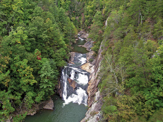
Tallulah Gorge Falls. Photo by Cindy Montgomery
If one waterfall a day just isn’t enough for you, the spectacular, 600-to 1,000-foot deep Tallulah Gorge in northeastern Georgia houses six separate waterfalls with a vertical drop of over 500 feet in less than a mile. The tallest is the gushing Hurricane Falls at 96 feet. Other falls in the drop include Tempesta (76 feet), the Oceana (50 feet), the l’Eau d’Or, pictured, (prounounced Lador, 46 feet), the sliding rock at Bridal Veil (17 feet) and Lovers Leap (16 feet).
The beauty of Tallulah Gorge has drawn visitors since the early 1800s. In 1913, Georgia Power built a hydroelectric dam at the mouth of the gorge to run Atlanta’s streetcars. The main section of the gorge—with its six spectacular waterfalls—was spared; however, the company diverted the water far downstream from the falls. As much as 10 times the amount of water ran through the gorge before 1913 as does today.
The 3-mile rim trail and a trail along the gorge floor provide alternate views of the falls, and scheduled releases from Tallulah Falls Lake in early April and November lure whitewater enthusiasts and people eager to see the falls in their original glory.
Located right off of U.S. 23/441, Tallulah Falls State Park (co-operated by the Georgia park system and Georgia Power) features camping, hiking, mountain biking, fishing, swimming and picnicking. Visit gastateparks.org/TallulahGorge for more information.
PA / Ohio — Cedar Falls
By Jared Shultz
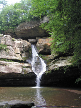
Cedar Falls. Photo by Thomas Ramsey
Cedar Falls, located in the remote valley of Queer Creek in southeastern Ohio’s Hocking Hills State Park, is a great example of how man has worked with nature in both antiquated and modern ways.
In the mid-1800s, Cedar Falls was the site of a grist mill that ground grain with the help of water power. Now that the falls are an attraction for modern hikers and outdoor enthusiasts, they are home to an integrated staircase known as Democracy Steps. Born from the mind of artist, architect and mathematician Akio Hizume, the 100 steps were deliberately designed to evoke feelings of calm and relaxation in the visitor. The ecology of the falls features snapping turtles and stands of hemlock once mistaken by early white settlers for cedars, hence the name.
The state first purchased the land for the park in 1924 in order to preserve its many natural features, including Old Man’s Cave, Ash Cave, Rock House and Cantwell Cliffs. Once home to the Adena culture 7,000 years ago, and a passageway or temporary home for tribes like the Wyandot, Delaware, and Shawnee as recently as the mid 1700s, the park now acts as a sanctuary for residents of the region.
From Columbus, get on OH-664 S, follow for 53 miles and the highway will lead you directly into the park. Hiking to Cedar Falls itself takes just a half a mile from the parking lot. See hockinghills.com for more details.
Related Articles
Latest News

Leave a comment
Your email address will not be published. Required fields are marked *


