By Joe Tennis and staff
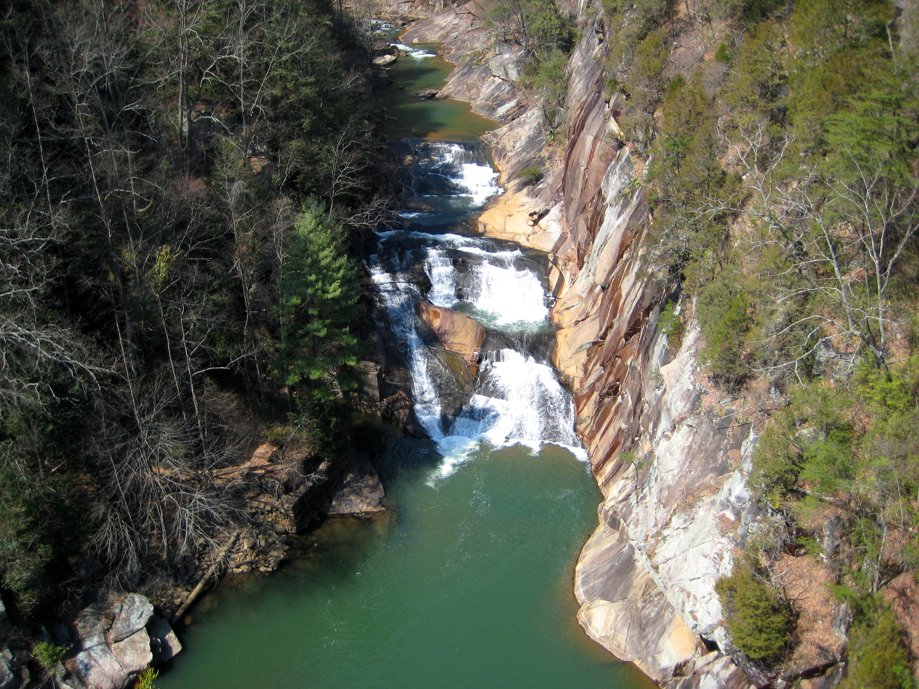
View of L’Eau d’Or Falls from Overlook #2. Photo by Tallulah Gorge State Park
We marched up and down the stairways of the Tallulah Gorge. That’s what you do at Tallulah Gorge State Park: You march.
You also stroll, rest and maybe march some more. Depending on the route you choose, seeing the gorge at this park can become a communal experience of endurance.
Come during winter, you’ll find solitude.
“In the winter, it’s slowest,” says Jessica James, the assistant park manager. “But every other time of year pretty much stays busy.”
Best yet, plan for one of the weekends in November or April when the Tallulah River rushes through the gorge at historic levels, showing what the river looked like before dams were built in the area. During these annual dam releases, you can see the full majesty of the gorge’s six waterfalls, captured on film for the classic Burt Reynolds adventure movie “Deliverance,”and watch kayakers paddle the famed whitewater.
On the North and South Rims, easy to moderate trails lead to overlooks that provide views into the gorge. A new overlook, added in the spring of 2014 just outside the visitor center, provides an easily accessible view of the suspension bridge at the bottom and a portion of the park’s tallest waterfall, the 96-foot Hurricane Falls.
Signs point the way all around the park, allowing visitors to combine their own hikes out of the nearly 20 miles of trails. “I think most people are looking for a fun adventure,” says Jonathan Bast, an interpretive ranger at the park. “We offer both ends of the spectrum — from real easy to real difficult.”
One popular option is to hike the approximately two-mile Hurricane Loop, which combines parts of three trails and leads into the steep gorge, past Hurricane Falls, and back up the other side. But with 1,099 stairs to traverse, this trail is rated difficult, so do not attempt this trail if you have any known health conditions.
Start out by heading down the 310 steps to the bridge suspended 80 feet above Hurricane Falls. Some folks choose to turn around here. “It’s just enough of a challenge that everybody can complete it,” Bast says.
On the far side of the bridge, another 221 steps descends to the riverbed. The trail then climbs up a serious set of stairs to join with the South Rim Trail. Turn left to take the quick out-and-back half-mile walk to Overlook #10 for stunning views of Oceana Falls, and then head back around the South Rim to cross U.S. 441, and connect with the North Rim Trail, catching glimpses of L’Eau d’Or and Tempesta falls along the way back to the Interpretive Center.
Continue an additional half-mile hike to Inspiration Point to see the gorge’s deepest spot — and one of the best views in the park — at nearly 1,000 feet.
For the more intrepid adventurer, the Gorge Floor Hike — rated very difficult — is accessible just below the suspension bridge, and ends at Bridal Veil Falls and Sliding Rock, the only place to swim in the gorge. According to James, traversing the gorge floor is “more like rock hopping and bouldering,” and the three-mile round trip can take three-to-four hours. “And there’s no designated trail. There are some places where you have to sit and crab-walk. I would say most people would feel a little bit out of their element [on this hike].”
Rangers issue only 100 permits a day, and demand is high — the park often runs out by 8:30 in the morning. “It’s for safety reasons and to protect the natural resources,” she says.
Due to the risk of getting wet, hiking the gorge floor might be most comfortable during the hotter times of year, James adds, but even in the winter permits are available most days.
That’s why taking the Hurricane Loop proves more popular and accessible, especially in winter months. But, even then, be ready for lots of huffing and puffing. Going straight up all those stairs is exhausting, though satisfying.
“I think it still feels like a wild and scenic place here in the Northeast Georgia mountains, even as it continues to increase in population,” James says. “We get about 300,000 visitors a year.”
Joe Tennis is the author of “Virginia Rail Trails: Crossing the Commonwealth” (The History Press, 272 pp., $19.99, 2014).
Related Articles
Latest News
More Stories

English Language Learning in Appalachia
Learning English is always difficult. But current aggressive approaches to immigration policy are creating more barriers for learners and the programs that serve them than ever before in Appalachia and beyond.

Pike County Rejects Mega Landfill
Many residents of Pike County, Kentucky, are breathing a sigh of relief since county commissioners finalized their decision to rescind a contract with an out-of-state waste management company.

Overdrive: Fossil Fuels in Appalachia
Electricity demand is on the rise. Here, we share snapshots of energy trends in the region and how methane gas, coal and data centers are affecting our communities — and how people are pushing back.

Less Support for Communities with Mine Problems
The Trump administration issued a regulation to weaken the Ten Day Notice process that helps community members call in federal enforcement when state regulators don’t do a good job policing environmental problems at coal mines

Chaos at the Tennessee Valley Authority, Cuts to Public Input
The past year has brought turmoil and uncertainty to the Tennessee Valley Authority, the nation’s largest public power provider, and its more than 10 million customers across the Tennessee Valley.

Landmark Coal Ash Protections Under Attack
The U.S. Environmental Protection Agency is planning to eviscerate important, hard-won regulations on coal ash, a toxic waste left after burning coal for energy.

Leave a comment
Your email address will not be published. Required fields are marked *
Leave a Comment