Front Porch Blog
New map shows more acreage disturbed per ton of coal mined now than 30 years ago
Researchers from SkyTruth, Duke University, and Appalachian Voices recently released the first-ever peer-reviewed study of the year-by-year footprint of surface coal mining, including mountaintop removal mining, in Central Appalachia.
“The fastest way to put thousands of unemployed Appalachian coal miners back to work is to invest in reclaiming abandoned mine lands, particularly in ways that lead directly to diverse economic development,” says Matt Wasson, director of programs with Appalachian Voices. “This is exactly the tool that is needed to understand where and when mining has occurred and to prioritize the cleanup of these dangerous and polluted sites.”
The study, published in the Public Library of Science’s multidisciplinary Open Access journal PLOS ONE, found that:
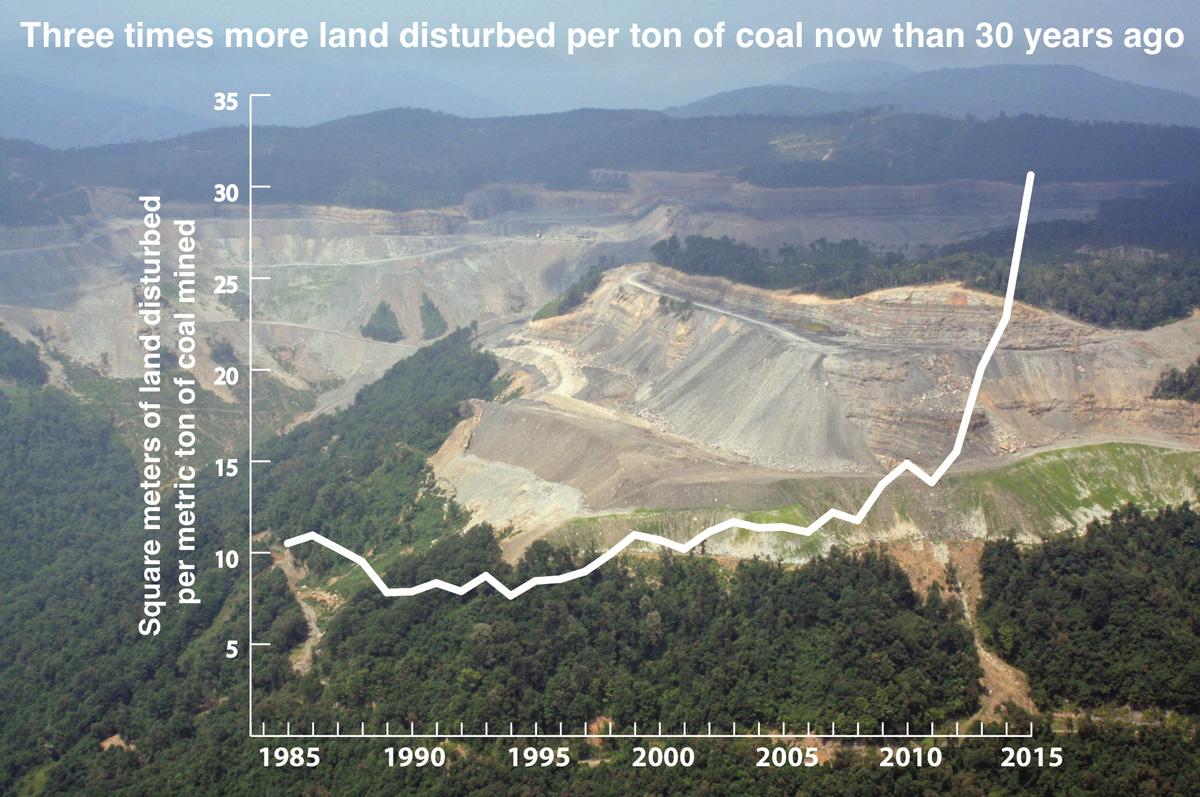
- Surface mining, including mountaintop mining, has been responsible for clearing 2,900 km2 (~720,000 acres) of land between 1985 and 2015, or 3.5% of Central Appalachia. When coupled with an earlier dataset covering the mid-1970s through 1984, the total amount of cleared land due to surface mining reaches 5,900 km2 (~1.5 million acres), accounting for 7.1% of Central Appalachia—or one out of every fourteen acres. Put another way, the total area is roughly three times that of the Great Smoky Mountains National Park.
- In the 1980s, 10 m2 (~110 square feet) of land was disturbed per metric ton (2,200 pounds) of coal produced. By 2015, 30 m2 (~330 square feet) was disturbed to produce the same amount of coal—a threefold increase.
Interactive map | Download the data set
The research team utilized Google’s Earth Engine cloud-based analysis platform, processing more than 10,000 individual Landsat satellite images. Their model identified areas with an absence of forest cover in contrast to surrounding, forested areas on a yearly basis. After excluding known roads, bodies of water, and cities, the team labeled any remaining deforested areas as likely surface mines, validated by manually spot-checking the results against aerial survey photography and other imagery. The semi-automated nature of the analysis allows the dataset to be updated annually.
“It’s important for policymakers, scientists and the public to see and understand the full scope of landscape disruption that Appalachia is burdened with as a consequence of our persistent economic dependence on coal mining,” says Christian Thomas, geospatial analyst with SkyTruth. “Google Earth Engine is a powerful tool for making this legacy visible and measurable, the first step toward envisioning a new future for the region.”
The research for this study was made possible by funding from National Science Foundation, Wallace Genetic Foundation, Cornell Douglas Foundation and Foundation for the Carolinas.
“These new data will enable a variety of new scientific research inquiries to better understand the environmental and human health impacts of mountaintop coal mining. Researchers will be able to align historic data on water quality or species distribution, for instance, with this new understanding of exactly when and where mining occurred,” says Andrew Pericak, research analyst with Duke University. “And I’m excited for future updates to these maps so as to facilitate up-to-date studies.”
PREVIOUS
NEXT

Leave a comment
Your email address will not be published. Required fields are marked *
One response to “New map shows more acreage disturbed per ton of coal mined now than 30 years ago”
-
It strongly appears that the impacted unemployed will have to vote far differently than they did in 2016, in order to obtain jobs that benefit their own water, air, forests, environments.
While even such republicans as highly conservative 1960s Goldwater maintained policies improving US lands, air, water, wildlife, that party has become instead the party most eager to destroy US jobs, along with the destruction of all of the above.I speak from the US west, quit familiar with many more areas devastated by toxic mining, right here in forested mountains, and having traveled, largely in less populous areas than those of Appalachia, experiencing the poisoned and leaking products from high mountain to desert mining.
While it may not appear to you that your mining affects any but a small area surrounding a mine, huge watersheds, goundwater, and the increasingly fragmented and diminishing wildlife populations invisible to the urban-centered world of the east, are dying in accelerating numbers.
This includes amphibians, and such wide-ranging animals as the 18-Million0year old Salmon species, now extinguished in a vast proportion of their former range in the uSA.You need to end ALL consideration of mining.
Leave a Comment