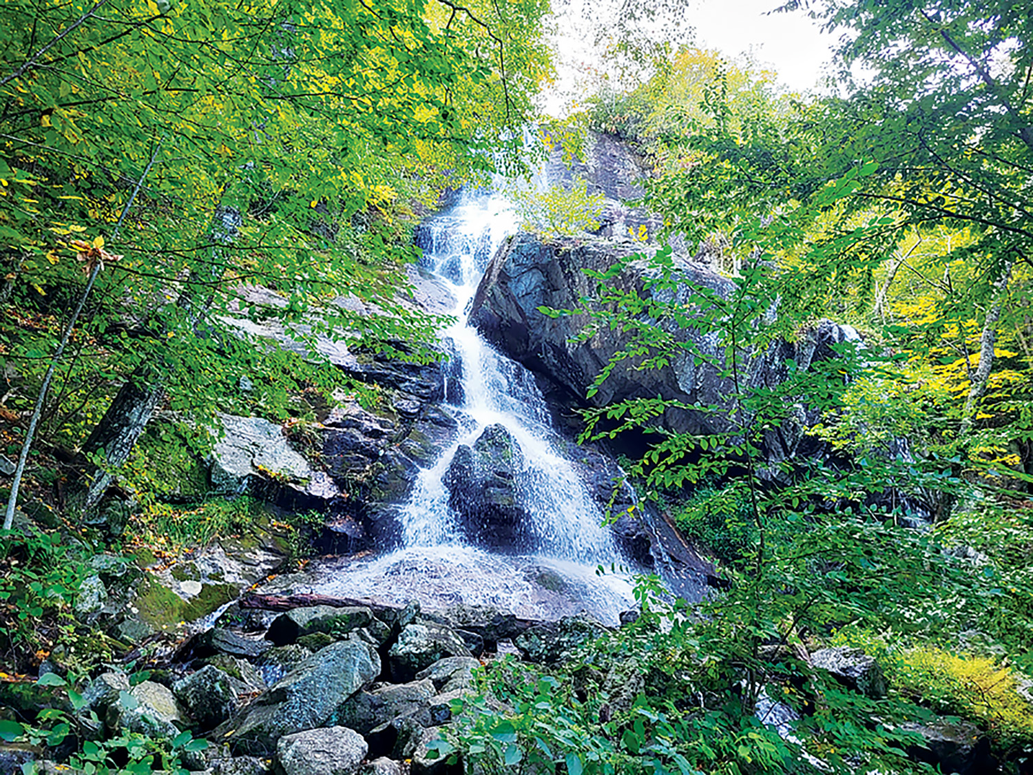
Apple Orchard Falls Trail, which crosses the Appalachian Trail, features a breathtaking 200-foot waterfall. Photo by Daniel Burnette
By Megan Pettey
Spanning 2,198.4 miles, the Appalachian Trail has long attracted nature lovers seeking refuge in the wild. While more than 3,000 people attempt to thru-hike it each year, according to the Appalachian Trail Conservancy, three million people visit and enjoy portions of the trail annually, embarking on day hikes and short backpacking trips. We asked folks which sections of the Appalachian Trail are their favorites, and here’s what we found!
Apple Orchard Mountain Lasso/Loop
Daniel Burnette and his father enjoy hiking Apple Orchard Falls Mountain Lasso, which intersects with the Appalachian Trail. For scenic views of these falls, pick up the 11.5-mile roundtrip loop at the end of Forest Service Road 59 in Botetourt County, Virginia. Due to a steep incline, Burnette says this trail is considered difficult.
“This hike covers the entirety of Apple Orchard Mountain, from the end of Forest Service Road 59, up Cornelius Creek, to the Radar Dome at the summit of Apple Orchard Mountain, and coming back down to Forest Service Road 59 via the Apple Orchard Falls Trail. There are three distinct biomes to see in this hike as the elevation gain is almost 3,000 feet on the north face of the mountain,” Burnette says. For a shorter trek, pick up the Apple Orchard Falls trail at mile 78.4 parking area on the Blue Ridge Parkway. The trail crosses the A.T. (northbound milepost 763) shortly after, and the 2.6 mile out-and-back route leads to stunning views of a 200-foot waterfall.
Roan Highlands
Many hikers are drawn to the mountain balds and forests found in the section of the Appalachian Trail between Carvers Gap (northbound milepost 377.3) and 19E (northbound milepost 391.6), according to Angela Shepherd at Southern Appalachian Highlands Conservancy, an organization that helps protect this ecologically diverse area.
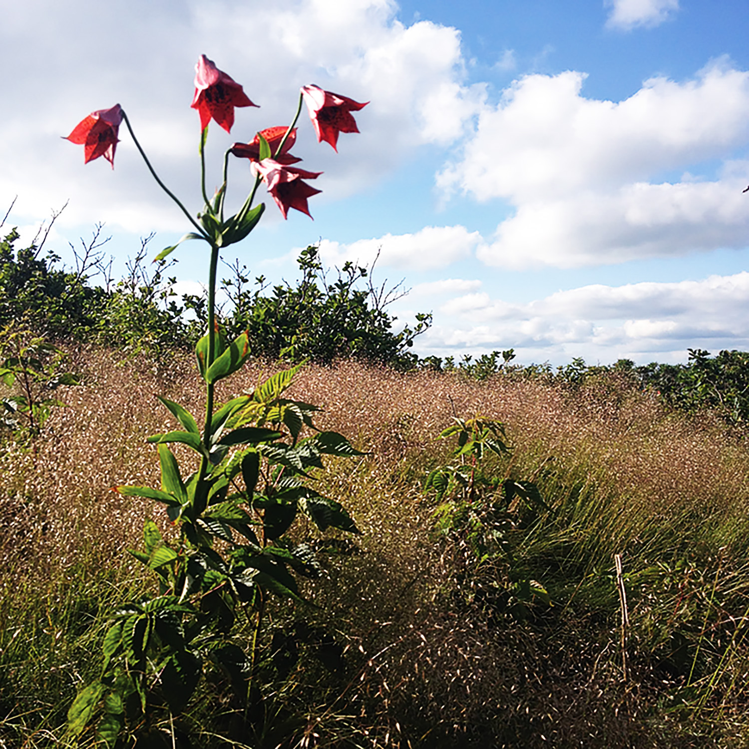
A Gray’s lily blooms near the Appalachian Trail as the path traverses a Roan Mountain bald. Photo by Molly Moore
Shepherd writes that it is “a popular section of approximately 14.3 miles which winds across the top of the balds with stunning 360-degree views.”
With colorful rhododendron and azalea blooms in the warmer months, these trailheads are especially popular in summer. The 6.7-mile stretch from Hughes Gap to Carvers Gap is another alternative for those wanting to wander through a variety of forest types, though Shepherd says both of these routes are challenging. She recommends the Cloudland Trail to Roan High Bluff, a 2.4-mile hike, as a more moderate option.
Shepherd advises hikers to be mindful of the abundance of rare plant and animal species while enjoying this part of the Appalachian Trail.
“It is very important for folks to stay on the trail and refrain from touching or picking wildflowers to help protect fragile ecosystems and endangered species,” she says.
Standing Indian to Nantahala Outdoor Center
Hiker Stacia Bennett recommends 52 miles of the Appalachian Trail that can be picked up in Deep Gap in Macon County, North Carolina, off Forest Service Road 71 (northbound milepost 85.4) and ends at the Nantahala Outdoor Center (northbound milepost 137.3).
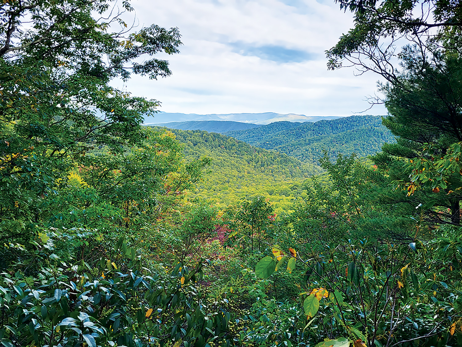
Many hikes along or connected to the Appalachian Trail offer vistas that are beautiful in every season, like this one in Botetourt County, Virginia. Photo by Daniel Burnette
“It was my favorite section of the trail when I attempted a thru-hike, and it remains my favorite,” Bennett writes. “I literally moved to Franklin (my favorite trail town — accessed in the middle of this section) to be near it.”
While this hike is sure to be a crowd favorite, Bennett says it’s less populated than nearby trails. With streams, rivers, three fire towers and stunning vistas, this part of the A.T. has plenty to offer for those looking to put in a little work.
“There’s a lot of climbing and descending, but the trail is well marked, well maintained, and in most cases moderately graded with reasonable switchbacks,” Bennett writes.
Newfound Gap to Mt. Cammerer
Amber Marie Gibbs recommends the Smokies section of the Appalachian Trail from Newfound Gap, Tennessee, (northbound milepost 206.8) to Mt.Cammerer, North Carolina (intersection with Mt. Cammerer Trail at northbound milepost 232.9).
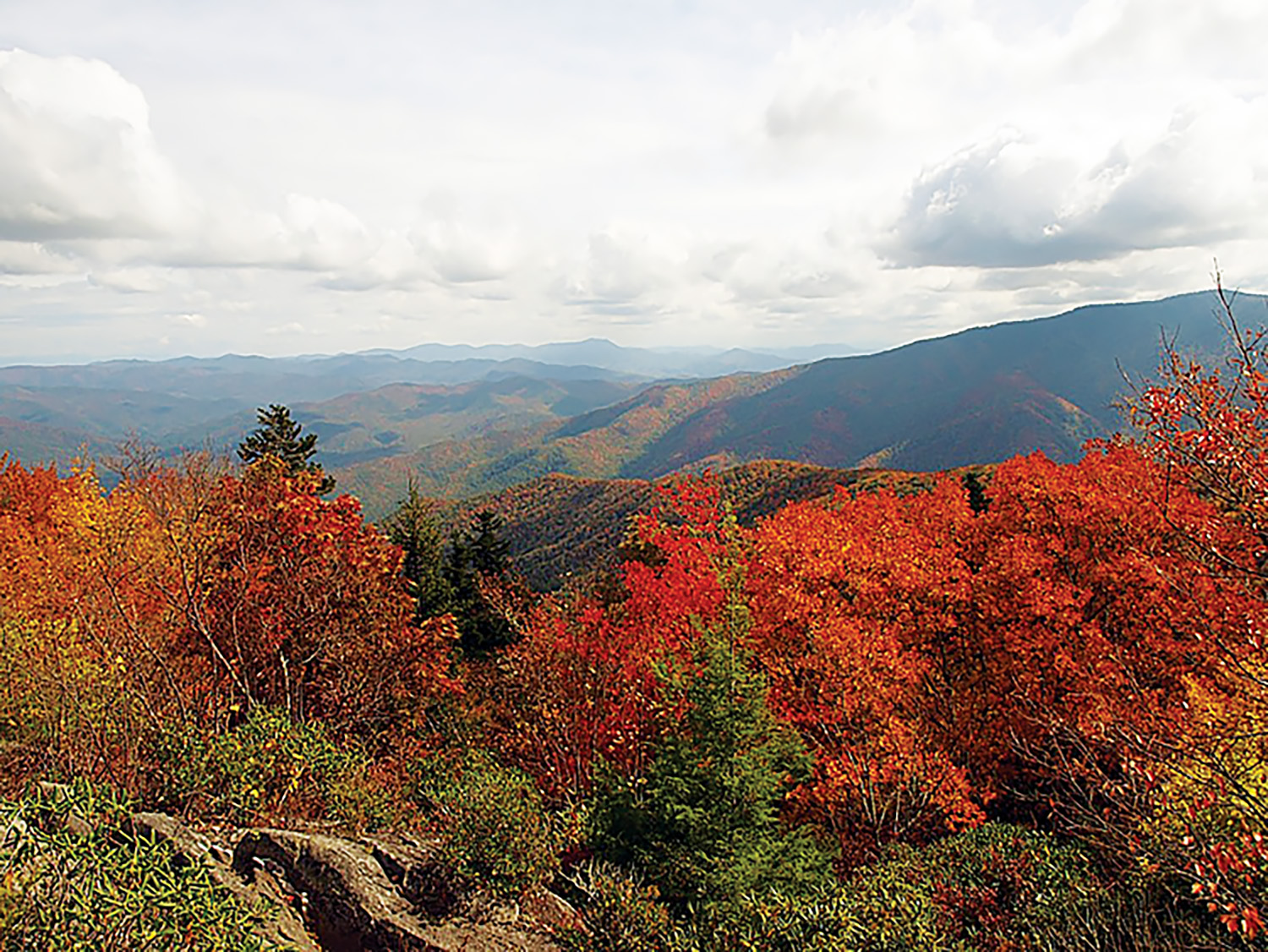
Stunning views, like this one from Mt. Cammerer, await hikers along the Appalachian Trail in the Smokies. Photo courtesy of NPS
“This area boasts several peaks over 6,000 feet with summits right off trail, incredibly well maintained trails and some of the coolest diversity (both in views and in habitats) in the southern segments,” Gibbs writes.
Hikers should be experienced and well prepared if they decide to take on this 26-mile trek. Starting at the ChestnutRidge Trailhead, past the intersection of Mount Sterling Road with Waterville Road, this hike offers a shorter option to see the peaks of Mt. Cammerer. This Option is 12 miles out-and-back, with a steep elevation gain of 3,200 feet.
Related Articles
Latest News
More Stories

English Language Learning in Appalachia
Learning English is always difficult. But current aggressive approaches to immigration policy are creating more barriers for learners and the programs that serve them than ever before in Appalachia and beyond.

Pike County Rejects Mega Landfill
Many residents of Pike County, Kentucky, are breathing a sigh of relief since county commissioners finalized their decision to rescind a contract with an out-of-state waste management company.

Overdrive: Fossil Fuels in Appalachia
Electricity demand is on the rise. Here, we share snapshots of energy trends in the region and how methane gas, coal and data centers are affecting our communities — and how people are pushing back.

Less Support for Communities with Mine Problems
The Trump administration issued a regulation to weaken the Ten Day Notice process that helps community members call in federal enforcement when state regulators don’t do a good job policing environmental problems at coal mines

Chaos at the Tennessee Valley Authority, Cuts to Public Input
The past year has brought turmoil and uncertainty to the Tennessee Valley Authority, the nation’s largest public power provider, and its more than 10 million customers across the Tennessee Valley.

Landmark Coal Ash Protections Under Attack
The U.S. Environmental Protection Agency is planning to eviscerate important, hard-won regulations on coal ash, a toxic waste left after burning coal for energy.

Leave a comment
Your email address will not be published. Required fields are marked *
3 responses to “Special Sections Along the Appalachian Trail”
-
The description of the AT across the Roan Balds is of very special interest to me. I of am a life long AT maintainer ( with the TEHCC ) and a founding member of the SAHC, a Land Trust
Like Max Patch, but even more spectacular, this section of the AT has been damaged by extensive overuse and disregard of proper trail manners. Much the same patterns of abuse were observed by the Seasonal Monitoring program of SAHC, and the TEHCC which maintains this and another 80 miles of the AT.
The Roan is the crown jewel of the very effective efforts to protect not only the Roan Highlands but now, a total of 100,000 Ac of endangered mountain land. SAHC is now 50 years old and one of the largest and most effective of the Regional Land Trusts.
There is a similar protection/restoration effort to parallel the Max Patch program for the heavily impacted Roan AT area. SAHC, the TEHCC , ATC and the USFS are working on this comprehensive plan.
Thanks to the excellent job done at Max Patch, this will be more rapidly implemented and the AT experience enhanced as well.
-
Peters Mountain along the WV and VA Border over looking Monroe, Summers and other WV counties to the west and Giles County VA to the east.
-
McAee Knob. Va
High Point NJ
Leave a Comment