Wandering through Pisgah Forest
By Elizabeth E. Payne
On Friday the 13th, I set out to Transylvania County, N.C., to spend the day exploring Pisgah National Forest with my brother. The Pink Beds Loop was rumored to have mountain bogs and plentiful wildflowers, and the hike did not disappoint.
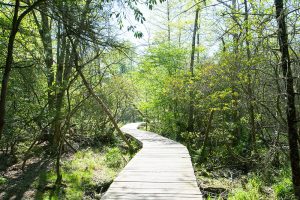
Newly constructed elevated boardwalks winds through the bog area, which beaver dams have expanded in size. Photo by Andrew G. Payne
The Pink Beds Valley was named by early settlers for the overwhelming number of rhododendron and mountain laurel blossoms that blanketed the area. According to the U.S. Forest Service website, “the name is more historic than descriptive,” since reforesting has changed the balance of the forest and these blooms — while present — no longer dominate the valley.
This area of Pisgah is part of the Cradle of Forestry, where the nation’s first school of forestry was founded in the late 1800s. The Forest Discovery Center is just down the road from Pink Beds, and its interactive exhibits bring this history to life.
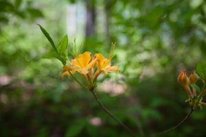
The flame azalea is just one of the many beautiful native plants you’ll encounter on this hike. Photo by Andrew G. Payne
The Pink Beds Loop is a nearly flat, oval-shaped trail measuring at least five miles. The wide path and orange blaze are easy to follow, although roots and ruts require some attention for footing.
What makes this hike spectacular is that with each twist of the path, the landscape changes dramatically. With one turn, the thick understory of tangled mountain laurel and rhododendron gives way to a forest awash in a sea of fern. Around another turn, dogwoods, doghobble, trillium or squawroot will be the treasure that catches your eye. I even spotted a lone gathering of Pink Lady’s Slippers.
The marked trailhead is at the far side of the Pink Beds parking lot. Follow the short path across the first small stream to reach the loop.
The trail crosses the South Mills River and its tributaries numerous times, and footbridges and rock-hop crossings make navigating the waterways easy.
Upon reaching the loop, either direction will result in an enjoyable hike. We chose to go left and walked the loop clockwise.
Pink Beds Loop
Difficulty: Easy to moderate
Details: 5-plus mile loop; muddy in wet weather.
Directions: From Brevard, N.C., take US 64 East. Turn left onto US 276 North for 11 miles. Past the Forest Discovery Center, the Pink Beds Picnic Area is on the right. Enter trail at far right of parking area.
More info: Contact Pisgah Ranger District at 828-877-3265 or visit tinyurl.com/PinkBeds
The oval is bisected by another trail, Barnett Branch, which you will first cross after about 1.5 miles. Turning onto Barnett Branch will cut across the center of the oval and make for a shorter hike. But to stay on Pink Beds Loop, follow the orange blaze straight.
At the midpoint of the loop, a side trail leads to the South Mills River gauging station, where there is a parking lot and an alternate trailhead for Pink Beds Loop.
As the path turns back for the return journey, the ground becomes wetter and the river crossings are wider. The path undulates through a carpet of fern, before rising out of the valley to catch glimpses of the mountains in the distance. And everywhere, bird songs provide the soundtrack of the forest.
After another mile, you’ll again cross the Barnett Branch path. Follow the orange blaze to remain on Pink Beds. (If taking the loop counterclockwise, the sign marking the Pink Beds Loop may be difficult to spot).
From here, Barnett Branch and Pink Beds briefly follow the same path, before Barnett Branch turns off across an elevated boardwalk through a grove of cinnamon ferns, which were just emerging as fiddleheads on the day we visited. This path is well worth a detour.
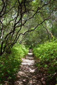
As you begin the loop clockwise, the path passes through tunnels of mountain laurel and rhododendron. Photo by Andrew G. Payne
As the Pink Beds Loop enters its final mile, we encountered one of the rarest of all Appalachian ecosystems —the swampy oasis known as the Southern Appalachian mountain bog.
The day we visited was fairly dry, but the area was still teeming with life. Sphagnum moss and tall, grass-like sedge plants abound, nestled beneath pine and maple trees. While I didn’t see any, the bog is also home to the threatened swamp pink flower and the carnivorous purple mountain pitcher plant.
Beaver dams have greatly expanded the area submerged by water in the bog, requiring one section of the trail to be shifted to higher ground and another to be crossed by nearly a quarter mile of elevated boardwalk.
A few more stream crossings will bring you to the end of the Pink Beds Loop. Turn left and go past the picnic area to return to the parking lot.
The quiet solitude and diverse wildlife make the Pink Beds Loop a nature lover’s dream.
Related Articles
Latest News


Leave a comment
Your email address will not be published. Required fields are marked *
No sphagnum moss. That is usnea. Very beneficial plant.