Front Porch Blog
Guest post: New SkyTruth research reveals legacy of mountaintop mining — and the policy implications
This map shows the extent of mining on the Hobet 21 mine, detected between 1985–2021, displayed in red. The areas delineated in green on this map are locations where we see indicators of positive vegetation recovery on previously mined lands. The inset map provides a close up of an area that was previously cleared for mining, and shows that vegetation is established on the site.
 Guest blog: Christian Thomas leads SkyTruth’s resource extraction monitoring work, both on land and at sea, focusing on surface mining, offshore infrastructure development, and marine pollution events. In addition to applying his background in geographic information systems (GIS) and remote sensing, he has helped to design lessons for SkyTruth’s educational outreach program. Christian is a native of Shepherdstown, West Virginia who joined the SkyTruth team after graduating from West Virginia University with a B.S. in Geography and Environmental Geoscience. (This was initially posted February 16, 2023, on the SkyTruth website)
Explosives and heavy equipment: the perfect combination for mine owners to extract coal from a pristine Appalachian landscape. Too bad this process, known as mountaintop removal mining, is terrible if you live near the mined mountain, or in a watershed downstream, or on a planet faced with the imminent threat of ever-increasing temperatures brought about by greenhouse-gas emissions.
Just this week, the environmental nonprofit Kentuckians For The Commonwealth published a letter, addressed to US Department of the Interior Secretary Deb Haaland, urging an investigation into whether a history of surface coal mining worsened deadly flooding in Eastern Kentucky last July. The group also published an interactive map to visualize the issue, drawing on SkyTruth’s existing mountaintop removal mining dataset.
Not only is mountaintop removal mining extremely harmful to the environment, but its harm is extremely long-lasting, according to new research — published in Restoration Ecology — we conducted with help from Appalachian Voices, Colorado State University, the University of Nevada, and the University of Wyoming. We discovered that 92% of mined lands we studied have yet to reach a state in line with healthy Appalachian forests.
If you’ve followed our work, you’re likely pretty familiar with the practice of mountaintop removal mining already. It’s an immensely destructive method of coal extraction favored in Central Appalachia, deforesting swaths of land before blasting the tops off of mountains with explosives. Most of the material that’s taken off the mountain, called overburden, is then deposited in nearby valleys—a practice creatively known as Valley Fill. What’s left are the seams of coal coveted by the mine owners.
Since the mid-2000s SkyTruth has been working with teams of researchers and environmental advocates to map the extent of surface mining and better understand its long-term impacts on the region. It’s of particular concern given the scope of mining in Central Appalachia, where it is the primary driver of landscape change with impacts that extend beyond the initial disturbances.
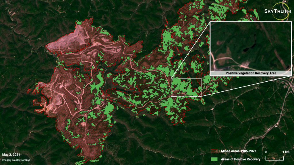
This map shows the extent of mining on the Hobet 21 mine, detected between 1985–2021, displayed in red. The areas delineated in green on this map are locations where we see indicators of positive vegetation recovery on previously mined lands. The inset map provides a close up of an area that was previously cleared for mining, and shows that vegetation is established on the site.
Drawing on our 2021 Central Appalachian Mine Reforestation Assessment, we set out to answer the following questions in our new study:
- What is the state of forest recovery for mined areas across Central Appalachia?
- Do external factors such as precipitation and site elevation help explain forest recovery?
Our new analysis builds off our previous work in several ways. For one, it draws on our dataset of annual mining footprints, first published in 2018. We began by filtering the dataset to look at areas we identified as active between 1985–2014, excluding mines identified after 2014. This dual filter not only helped exclude areas still actively being mined, but also ensured that enough time had passed to ensure valid assessments of vegetation.
The growth of mountaintop mining operations over 30 years, shown near Charleston, W.Va. The footprint of the mines is displayed in yellow.
For each site, we assessed a set of key metrics calculated from Landsat imagery: the Normalized Burn Ratio (NBR), a useful measure for monitoring short- and long-term vegetation recovery as well as forest structure; the Normalized Difference Moisture Index (NDMI), which provides information about the moisture content of soils and vegetation; and the Normalized Difference Vegetation Index (NDVI), an indicator of photosynthetically active vegetation (a measure of vegetation intensity, to put it another way).
Together, these metrics serve as indicators of overall vegetation health. Once we had compiled annual statistics for each metric, we set out to directly compare them to data from unmined, forested “reference sites.” The reference sites, located within the same EPA level 4 ecoregion (“areas where ecosystems are generally similar”) as the mined ones, provide a basis for comparison to the inactive mines.
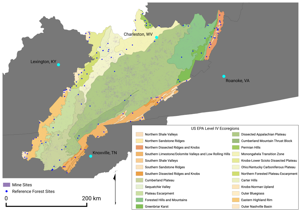
This map shows the Central Appalachian study area, with each of the US EPA level 4 ecoregions it contains.
We utilized autoregressive models that analyzed the annual health of mined sites, which returned information about their equilibrium values (the state that a site is expected to reach), and their rates of recovery. The equilibrium values of mined sites were compared to the equilibrium values for reference forests to evaluate their health relative to similar, yet undisturbed, forests. Additionally, we calculated the probability that a site would recover to an equivalent, or even healthier state than reference forests.
In addition to examining site performance in relation to reference sites, we explored the impacts of several physical variables on mined land recovery. For each site, we examined the effects that total area of disturbance, mean slope (a control on vegetation structure), mean elevation (given the variability across the study area), and average annual precipitation (an indicator of growing conditions) have on a site’s rate of recovery.
Our research returned daunting results. Only 7.9% of mine sites have recovered to a degree that is consistent with the conditions present on our reference forest sites. Unsurprisingly, we found that most of the mined lands we studied were heavily degraded, and their poor conditions persisted for decades.
This map shows the Central Appalachian study area, with each of the US EPA level 4 ecoregions it contains.
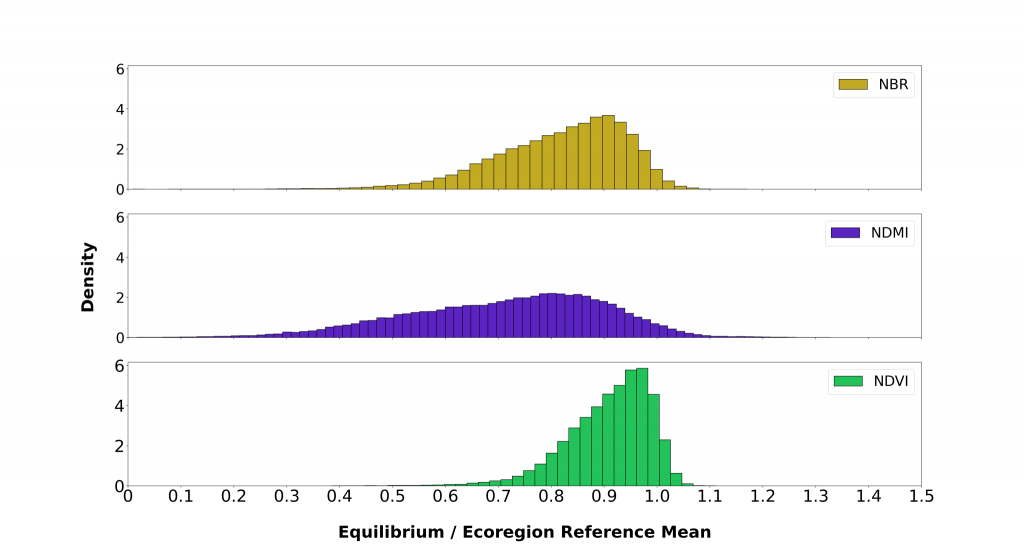
Histograms for normalized burn ratio (NBR), normalized difference vegetation index (NDVI), and normalized difference moisture index (NDMI) detailing the recovery benchmarks for mined sites, as measured by comparing the site’s equilibrium value to the mean value for undisturbed forests (site equilibrium divided by ecoregion reference mean) in the same EPA level 4 ecoregion.
To understand this land change in context, it’s important to consider the influence of government policy. In the early 2000s a new approach to mine-land restoration, called the Forestry Reclamation Approach (FRA), was developed to facilitate recovery and support the reestablishment of native Appalachian forests on mined lands. This relatively new approach has not been widely implemented; it represented only 2.2% of the mines we examined. The FRA is very promising in its ability to more adequately restore mined lands; we observe that all FRA sites have attained a level of recovery that is 75% of the value seen at our reference sites. By contrast, non-FRA sites lagged behind, failing to reach that same 75% threshold across all our measures: 4% of non-FRA sites fell short in NDVI, 27% in NDBR, and a whopping 53% in NDMI.
Another key policy, the Surface Mining Control and Reclamation Act of 1977 (SMCRA), has heavily influenced what the legacy of mountaintop removal mining on the landscape should be. SMCRA includes a clause requiring mined land be restored to a state such that it is capable of “supporting the uses which it was capable of supporting prior to any mining, or higher or better uses.”
Since its passage, there has been substantial ambiguity in the interpretation of this clause, especially around “higher or better use.” Acceptable post-mined land uses include cropland, forest (either managed or unmanaged), residential, light industrial, and fish and wildlife habitat, to name a few. The breakdown of post-mined land use by state varies, but forest is one of the most common listed—and there are requirements for what this restoration includes:
- Restoring the original contours of the land (mine operators are able to apply for variances to the original contour).
- Establishing native vegetation that is diverse, effective, and permanent.
SkyTruth calls West Virginia home, which makes us acutely aware of the value Appalachian forests add to daily life. They represent an important commons for community members, who use them for hunting, fishing, hiking, and foraging for ramps, ginseng, and mushrooms. These are areas that deserve to be restored, so these activities can be continued in the future.
As coal production in the region continues to decrease from its high in 2008, local communities and environmental advocates face a key question: What is the legacy of mountaintop removal mining operations?
While the state of mined land recovery is disappointing in Central Appalachia, it is important to highlight that restoration is an ongoing process. The actions that regulators or mine operators take today can dramatically improve a site’s recovery in the future, with major implications for local ecosystems and people.
We hope our research and data will allow regulators to better assess recovery efforts. That way they can identify areas in need of additional resources or investments, as well as ensure mine operators are held accountable for living up to their reclamation obligations. In situations where companies’ restoration efforts are falling short, transparency and clear visual evidence can help protect our planet and communities.
PREVIOUS
NEXT
Related News

Leave a comment
Your email address will not be published. Required fields are marked *