West Virginia: Cheat River and Summersville Lake
| June 7, 2019
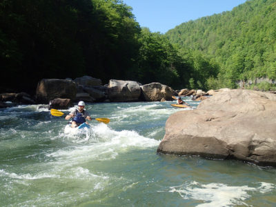
Paddlers enjoy the Cheat River. Thanks to the cleanup of abandoned mines and related acid mine drainage, the river has made a remarkable recovery. Photo by Garrett Thompson.
Location: The Cheat River flows north through northeastern West Virginia, near the towns of Rowlesburg and Albright.
Difficulty: The Upper Cheat north of Parsons is a Class I river with excellent camping and fishing opportunities. The river’s Narrows section is characterized by Class II and III rapids, though it can be more advanced during high water levels. This section is also home to Fascination Alley, a world-class squirt boating destination. The Cheat Canyon section is a 10-mile wilderness run with Class III and IV rapids, and is also the location of an annual May race that coincides with the Cheat River Festival, an environmental and music event. Many of the Cheat’s tributaries, like Red Creek, the Blackwater and Big Sandy Creek, are also whitewater destinations.
How to access: Find detailed access information for the beginner-friendly Upper Cheat at cheatriverwatertrail.org. For information on the advanced Narrows and Cheat Canyon sections, visit the American Whitewater website.
Fun Facts: The Cheat is clean and safe for paddlers today, but that wasn’t always the case. Acid mine drainage from upstream coal mining began noticeably damaging the river in the 1970s. In 1994, a mine blowout on Muddy Creek contaminated the river, dyeing the rockbed bright orange. But the crisis also led to the formation of Friends of the Cheat, a local advocacy organization that spearheaded efforts to restore the river and its tributaries.
Local Champion: Friends of the Cheat has been a key part of the successful effort to remove the Cheat from the state’s list of impaired waterways. The organization installed and maintains 15 treatment sites for acid mine drainage in the surrounding area, and helped the state maintain another 30 sites. In 2018, the group received a $3.2 million Abandoned Mine Lands Pilot Program grant to develop a trail system along the Narrows section and transform a former coal prep plant into a riverside park.
More info: Visit the Friends of the Cheat website to learn about the organization’s work, or contact them for river-related questions. For whitewater adventures, contact Cheat River Outfitters. — Molly Moore Summersville Lake
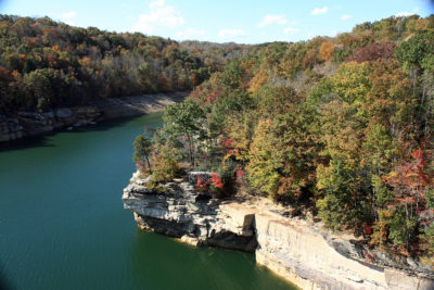
Location: Located in Nicholas County, W.Va., Summersville Lake is situated near the Gauley and New rivers, two of the state’s best-known whitewater rivers. The lake is formed by a rock-fill dam on the Gauley.
How to access: The lake connects to the Gauley River National Recreation Area and is highly accessible to the public. The lake’s proximity to the Gauley and New Rivers makes it a great spot for those looking to enjoy alternative water recreation after whitewater rafting.
Difficulty: The lake allows many recreational activities beyond paddling, including stand-up paddleboarding and scuba diving, which vary in difficulty.
Fun Facts: On the cliffs surrounding the lake is West Virginia’s only working lighthouse, the Summersville Lake Lighthouse.
Local Champion: The U.S. Army Corps of Engineers Huntington District manages the lake and coordinates volunteers who serve as beach and campground hosts or help with service projects. Nicholas County High School students are also involved in lake clean-ups.
More info: Active Southern West Virginia, a group that promotes physical activity, occasionally holds free stand-up paddleboarding days on the lake. Check activeswv.org/events for details. To learn about the lake and its regulations, visit summersvillewv.org/summersville-lake. — Sam Kepple
Related Articles
Latest News

Leave a comment
Your email address will not be published. Required fields are marked *
