Rebuilding Roads and Rethinking Rivers
A tale of two rivers after Hurricane Helene
By Erin Savage
In September 2024, Hurricane Helene slammed into the Southeast, resulting in extensive flooding, landslides and treefall. The storm devastated human lives, homes, businesses, roads, thousands of acres of forest and many rivers.
While rivers in Appalachia are prone to more mild flooding, the changes some rivers experienced during Helene were beyond what many imagined possible. The storm filled rivers with debris, moved house-size boulders and, in some cases, even ripped off huge slabs of bedrock.
Following the storm, some rivers have continued to be significantly altered by reconstruction of highways, interstates and railways. Now, the fate of these rivers depends on what condition they are left in as recovery projects are completed.

Simplified map of major rivers in North Carolina and Tennessee that flooded significantly during Hurricane Helene. This map does not include all rivers where flood damage occurred. Map provided by Appalachian Citizens’ Law Center
The Appalachian Mountains are old mountains, worn by millions of years of erosion. This has left behind lush forests, clear water, and smooth, stable riverbeds perfect for recreation, as well as an abundance of biodiversity. Residents and tourists alike utilize many of the region’s rivers for fishing, tubing, paddleboarding, kayaking, rafting, swimming or hiking alongside. People visiting Western North Carolina to float a river contribute nearly $40 million in economic impact to the region annually — and that’s from an economic study back in 2017.
Here, human life is also often organized around rivers, and a large percentage of roads, highways, railways, powerlines and even town centers are located along rivers. Relocating infrastructure, even after a major flood, may not be possible due to the steep terrain.
Helene destroyed many roads across the region. Interstate 40 along the Pigeon River and Highway 74A through Bat Cave and Chimney Rock Village have been two of the most time-consuming rebuilding projects.
These two roads also include treasured recreational stretches of river. As recovery takes place, communities must grapple with how to balance repairing infrastructure, preserving and repairing the structure of these rivers, and protecting aquatic life.
The Pigeon River
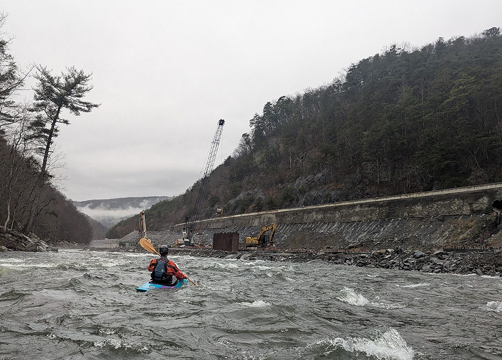
The Pigeon River flows northwest from North Carolina to Tennessee through a deep river gorge and thick Appalachian forests. Its most popular stretches for kayaking and rafting run alongside Interstate 40 in Tennessee, but maintain a wild feel due to the surrounding national forest and Great Smoky Mountains National Park.
The river flow in these stretches is controlled by a hydroelectric dam operated by Duke Energy. The company currently provides predictable recreational flows in the Pigeon Gorge, which contains friendly class III rapids perfect for commercial rafting. Multiple outfitters provide guided trips on this stretch.
The section of river at the North Carolina state line above the powerhouse, known as the Pigeon Dries, contains class IV and V rapids. The Dries are not boated commercially, but are a draw to private boaters around the region when heavy rains cause the dam to spill directly into this section.
Hurricane Helene damaged 11 miles of Interstate 40 along the Pigeon River in North Carolina and Tennessee. The North Carolina Department of Transportation estimates that 3 to 4 million cubic yards of material from the roadbed were washed into the river during the flood. Now, both states are undertaking a massive project to repair the interstate. The rebuild is scheduled to be completed by late 2027 in Tennessee and by late 2028 in North Carolina.
To conduct the project, a temporary access road was constructed in the river channel below the interstate. The access road has constricted the Pigeon by as much as 50% in some areas. Due to the need for fill material to rebuild the interstate, NCDOT has opened a rock mine alongside the river in Pisgah National Forest.
To offset the environmental impacts of the mining operation, NCDOT will improve low-water road crossings, construct wildlife crossings and purchase over 1,000 acres of land to be added to the national forest.
Despite the extensive construction activity alongside the river, commercial rafting resumed in 2025. The NCDOT constructed a new river access area about a mile downstream of the original put-in, which was located just below Duke’s powerhouse.
While the river still has hydraulic features that make a raft trip exciting, it is clear that the riverbed and riverbanks will continue to change throughout the construction project. In some areas, fill material chokes the river bottom, taking away eddies good for both boaters and aquatic life.
“In that first mile of river, we lost all the rapids,” says Steven Foy, general manager of outpost operations at the Nantahala Outdoor Center, which runs raft trips on the Pigeon. “All along the 5-mile run, there were massive rocks that just disappeared. From a whitewater perspective, it’s not the same.”
Foy is hopeful that the state of Tennessee will identify funding to reconstruct in-stream features.
In addition to recreation, the Pigeon provides important habitat for native aquatic life. The upstream headwaters are home to the endangered Appalachian elktoe mussel, which has been found surviving in pockets of the West Fork of the Pigeon River after Helene.
Further downstream, where a now-closed paper mill and the hydroelectric dam impact the Pigeon, both North Carolina and Tennessee have had success in reintroducing a number of aquatic species, including fish and mussels.
The Pigeon River Gorge is also home to many land-based species. Advocates with the Safe Passage Coalition have worked for nearly a decade to secure safe wildlife crossings of I-40 in the Pigeon Gorge to protect bear, elk and other wildlife as well as drivers and passengers.
The coalition hoped that the rebuild would be an opportunity to improve wildlife crossing features, but federal reimbursement constraints may limit what is possible.
Though the rebuild will fix an existing wildlife crossing at an interstate-wide tunnel, the coalition argues that the massive retaining wall being installed and the failure to enlarge existing culverts will create ongoing dangers for wildlife in the gorge.
Kevin Colburn, national stewardship director for American Whitewater, is hopeful about the long-term future of the Pigeon River, both in terms of recreation and ecology.
“Success depends on what they leave behind when they leave the river,” Colburn says, referring to the need for each state department of transportation to have a clear plan for removing temporary roads and restoring natural river structure. He notes that rebuilding a natural riverbed creates variations in flow that provide good aquatic habitat, interesting recreational features and flood resilience all at once.
The Rocky Broad River
On the opposite side of the Eastern Continental Divide, the Rocky Broad River runs southeast toward the Atlantic. Unlike the Pigeon, there was no commercial rafting on the Rocky Broad. Before the storm, the steep, small riverbed was better suited to expert kayakers and canoeists. But the area does rely heavily on tourism — Chimney Rock State Park, Chimney Rock Village, rock climbing and fishing all draw large numbers of visitors. Hickory Nut Gorge, where the Rocky Broad lies, is steep and narrow. The highway ran right next to the river in many places, and commercial shops drew tourists with their riverside locations.
Located on the North Carolina Blue Ridge escarpment that separates the piedmont and the mountains, the Rocky Broad watershed received a massive amount of rainfall across all of its headwater streams during Helene. The floodwaters washed away many sections of highway through the gorge, as well as many bridges, homes and commercial buildings.
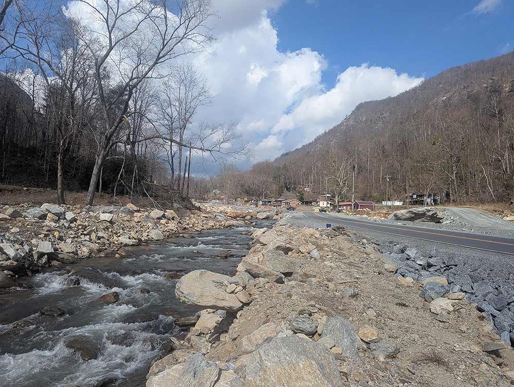
The North Carolina Department of Transportation has constructed a temporary road within the Rocky Broad River channel while the permanent road is constructed. The temporary road serves not only as a construction access road, but also as a temporary public road for residents and visitors. In some places, the temporary road appears to travel directly down the middle of the riverbed, constricting the Rocky Broad to half its normal width on one side, and leaving large ditches on the other.
While the current road is temporary, here, too, it is unclear what condition the riverbed and riverbanks will be left in when the road is removed.
Local residents of Chimney Rock Village have a vision for the river and its banks when highway construction is complete. Following the storm, the municipality formed the Chimney Rock Village Task Force, composed of local leaders, residents, business owners and nonprofit staff. The task force held many meetings and two public workshops, and solicited expert analysis and planning from several design and engineering firms. The work culminated in the Raise the Rock Recovery Action Plan. The comprehensive recovery plan includes a rebuilt and expanded riverwalk, as well as expert construction of in-stream features that could improve hydrology for both aquatic life and people enjoying innertubes, paddle boards and kayaks.
Road construction along both the Pigeon and Rocky Broad rivers will take several more years. Meanwhile, these rivers will continue to change, often slowly, and sometimes rapidly, as new floods occur.
If left alone, the rivers will heal from the storm and construction in time. But decision-makers, residents and state and federal agencies have a chance to speed recovery, both ecological and economic, if they consider how riverbed and riverbank areas are left after road construction crews are gone.
River Cleanup of Helene Debris Continues
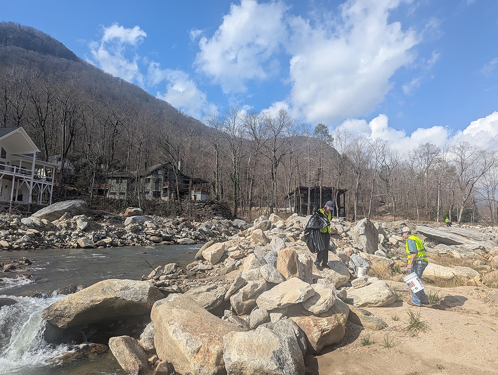
More than a year and a half after Hurricane Helene devastated communities across a swath of Appalachia and the Southeast, river recovery efforts are still underway. As the region continues to recover, a look at cleanup efforts in East Tennessee and Western North Carolina reveals lessons for improving the cleanup of public waterways after future floods.
“We knew that a federally funded effort would be necessary to remove the large debris, but we didn’t understand exactly how destructive that effort would be in terms of tearing up river banks, and removing live trees and large woody debris,” says Gray Jernigan, deputy director and general counsel for MountainTrue, a Western North Carolina nonprofit.
MountainTrue has received $10 million dollars in state funding and additional foundation funding, which has allowed the nonprofit to launch a massive river cleanup and restoration effort, hiring many displaced outdoor recreation workers.
Read more on river cleanup and debris removal at appvoices.org/helene-rivers.
Related Articles
Latest News
More Stories

English Language Learning in Appalachia
Learning English is always difficult. But current aggressive approaches to immigration policy are creating more barriers for learners and the programs that serve them than ever before in Appalachia and beyond.

Landfill Drama
Many residents of Pike County, Kentucky, are breathing a sigh of relief since county commissioners finalized their decision to rescind a contract with an out-of-state waste management company.

Overdrive: Fossil Fuels in Appalachia
Electricity demand is on the rise. Here, we share snapshots of energy trends in the region and how methane gas, coal and data centers are affecting our communities — and how people are pushing back.

Less Support for Communities with Mine Problems
The Trump administration issued a regulation to weaken the Ten Day Notice process that helps community members call in federal enforcement when state regulators don’t do a good job policing environmental problems at coal mines

Chaos at the Tennessee Valley Authority, Cuts to Public Input
The past year has brought turmoil and uncertainty to the Tennessee Valley Authority, the nation’s largest public power provider, and its more than 10 million customers across the Tennessee Valley.

Landmark Coal Ash Protections Under Attack
The U.S. Environmental Protection Agency is planning to eviscerate important, hard-won regulations on coal ash, a toxic waste left after burning coal for energy.

Leave a comment
Your email address will not be published. Required fields are marked *
Leave a Comment