By Dana Kuhnline
Bad Branch Falls near Whitesburg, Ky., was one of the first hikes I experienced when I moved to Appalachia almost 10 years ago. I happened to be chaperoning two vans full of at-risk teenagers on a weekend trip from West Virginia to Whitesburg. The last stop before heading home was this hike.
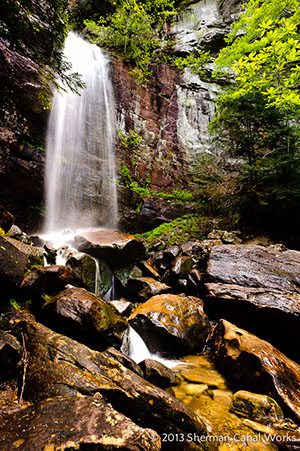
The rewarding day hike at Bad Branch State Nature Preserve connects to the Pine Mountain Scenic Trail, which spans 42 miles. Photo by Sherman Cahal, americanbyways.com
To get to Bad Branch State Nature Preserve from Whitesburg, you take U.S. Route 119 over the impressive Pine Mountain, a ridge stretching from Tennessee to Virginia formed when West Africa collided into North America more than 275 million years ago. Now the second-highest mountain in Kentucky, Pine Mountain’s views and hairpin turns left me gasping at the massiveness of geologic forces and the comparative smallness of 16 sleep-deprived youths gazing quietly into the endless green rolling hills.
I’ve traveled back to Bad Branch State Nature Preserve on the south side of Pine Mountain several times since it first impressed me with its diverse forest and ability to awe angsty teenagers. The preserve started as 435 acres in 1985, but has grown to more than 2,500 acres through a state partnership with several conservation funds. Its rich ecosystems contain a number of rare species of wildflowers, occasional black bears and Kentucky’s only known nesting pair of common ravens.
Once on the trail, it’s about a mile of steady uphill to a side trail that takes you to Bad Branch Falls. The well-kept trail climbs along the beautiful Bad Branch, a state-designated Kentucky Wild River. There are several small footbridges that make for easy crossing and pretty pictures. The shady gorge is filled with rhododendron and a healthy forest with a few impressive hemlocks that were spared from 1940s logging. The first mile is popular with local residents, possibly because the sandstone cliffs and 60-foot falls at the end are one of the best places in the world for a picnic.
Bad Branch Falls is impressive year-round, with perfect boulders to scramble over to enjoy the spray at the foot of the falls and startlingly green ferns to frame the rainbows that often appear in the splashing water. The waterfall is too popular to feel completely secluded, but the upshot is that there might be a friendly stranger handy to snap a group photo for you.
After you have finished sunning yourself on the rocks beneath the waterfall, or perhaps even taken a quick shower in the falls themselves, you can head back to the car or continue up to the High Rock Loop Trail, which is a steep two miles to the crest of Pine Mountain. If you make it to the top, you’ll be rewarded with stunning views off of the sandstone cliffs at High Rock. It’s a wonderful place to contemplate how this 125-mile-long ridge stymied early settlers, who were forced to travel to Whitesburg via this steep trail. Even today, there are few roads crossing Pine Mountain; its inconveniently rugged beauty has thus far protected it from extensive human development.
Watch the signs carefully, because at this point the High Rock Loop Trail meets with the Highland Section of Pine Mountain Scenic Trail, which travels north up and down the ridge for 42 strenuous, view-filled miles. If you have brought a map of the Pine Mountain Scenic Trail, you might enjoy checking out a few of the rock formations and overlooks along this adjacent section – but keep an eye on your time. The lot at Bad Branch does not allow overnight parking, so if you’re looking for a longer adventure along the ridge you’ll need to leave your car at the trailhead for Pine Mountain Scenic Trail located nearby on U.S. Route 119.
Though the journey back from High Rock Loop to the Bad Branch parking lot will revisit some of the same trail, the varied forest and peeks into the gorge keep the walk interesting. To me, the best walks have rock formations to scramble over, epic views or a waterfall. Bad Branch Falls State Nature Preserve has all three packed into a strenuous but rewarding day-hike just a few miles off the highway.
Bad Branch Falls, KY.
Where: Letcher, Ky., 8 miles south of Whitesburg, Ky. From US 119, turn left onto KY 932 (following signs for Bad Branch), travel east for 2 miles to gravel parking area on left side of KY 932.
Length: 1 mile to Bad Branch Falls, 5 miles round-trip to the crest of Pine Mountain along High Rock Loop Trail.
Facilities: None. Bring water or a water filter.
Pets: No pets are allowed at Kentucky State Nature Preserves.
Related Articles
Latest News
More Stories

English Language Learning in Appalachia
Learning English is always difficult. But current aggressive approaches to immigration policy are creating more barriers for learners and the programs that serve them than ever before in Appalachia and beyond.

Landfill Drama
Many residents of Pike County, Kentucky, are breathing a sigh of relief since county commissioners finalized their decision to rescind a contract with an out-of-state waste management company.

Overdrive: Fossil Fuels in Appalachia
Electricity demand is on the rise. Here, we share snapshots of energy trends in the region and how methane gas, coal and data centers are affecting our communities — and how people are pushing back.

Less Support for Communities with Mine Problems
The Trump administration issued a regulation to weaken the Ten Day Notice process that helps community members call in federal enforcement when state regulators don’t do a good job policing environmental problems at coal mines

Chaos at the Tennessee Valley Authority, Cuts to Public Input
The past year has brought turmoil and uncertainty to the Tennessee Valley Authority, the nation’s largest public power provider, and its more than 10 million customers across the Tennessee Valley.

Landmark Coal Ash Protections Under Attack
The U.S. Environmental Protection Agency is planning to eviscerate important, hard-won regulations on coal ash, a toxic waste left after burning coal for energy.

Leave a comment
Your email address will not be published. Required fields are marked *
2 responses to “A Waterfall and a View at Bad Branch State Nature Preserve”
-
Bad Branch Falls is one of our favorite hikes. The signs are a bit misleading. We’ve always tracked further to the falls & back. Looking forward to going on to High Rock but we have to do that first without out our children who love to hike with us (ages 9 & 3). This hike is truly what I call a public hidden gem. It’s known about yet it seems not many actually know where it is. Directions aren’t marked very well on the road. Come, bring a snack & enjoy a day at these beautiful falls!
-
fired up, ready to treck!
Leave a Comment