By Joe Tennis

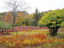
Autumn colors transform a roadside meadow in Dolly Sods Wilderness, near the Wildlife Trail. Photo by Joe Tennis
Julie Fosbender stepped carefully down the trail called Fisher Spring Run, heading downhill on a Monday morning. We hiked together for almost two miles along this unmarked-yet-mapped path in the Dolly Sods Wilderness, an expansive and scenic section of the Monongahela National Forest.
The Dolly Sods Wilderness is a hiker’s dream, spanning 17,371 acres of bog and heath eco-types, more commonly found in southern Canada. Elevations range from 2,500 feet to over 4,700 feet. The protected area takes its name from a German pioneer family — Dahle — whose livestock grazed the grassy area locally called “sods.”
Forty-seven miles of trails in the Dolly Sods Wilderness follow old railroad grades and logging roads, many of which contain creeks that must be forded.
Creek-hopping is generally easier in autumn, when it may not be raining so much, but could grow tricky in the spring.
Trails here range from the Red Creek (6.4 miles) to the Northland Interpretive (0.3 miles). To expand even further on the variety, multiple-trail hikes can be created by using two cars to form a shuttle, or combining parts of trails to form loops.
Choose Your Adventure
Starting at Fisher Spring Run Trailhead, just off Forest Road 75, Fosbender and I immediately descended into the wilderness, rambling over rocks as we passed a wealth of ferns and firs, including hemlocks and several fallen logs.
“This forest provides a range of experiences,” says Fosbender, the north zone recreation manager for the Monongahela National Forest. “And we rely on our visitors to self-select the experience that they want.”
Every once in a while along this trek, you’ll see a campsite with a fire ring left in place, beckoning hikers to extend their stay in Dolly Sods. Beware setting a fire outside of the ring, however; beginning in 1943, this area was used for maneuvers by the U.S. military, and many artillery and mortar shells shot into the area for practice still exist.
Although this sounds scary, a highly trained crew surveyed trails in 1997 for explosives and returned with 15 leftovers. Many more explosives could exist, however, which is why tried-and-true fire rings are best.
“The worry isn’t so much that there’s a bomb under our feet,” Fosbender says. “But if you light a fire, that could make that bad boy go off, and that could ruin your day.”
We did not see any bombs on this particular Monday, but our path on the Fisher Spring Run Trail grew increasingly pointy on the backs of rocks as it continued down the mountain.
At a crossroads of trails, Fosbender continued on Fisher Spring Run as I turned on the Rohrbaugh Trail (TR 510) — an even rockier road. At times on the Rohrbaugh Trail there were little, if any, signs of earth beneath my feet. The trail crosses a stream with a miniature cascade and then passes a cliff outcrop the size of a large car. It’s a shady path that requires careful footsteps.
After about a half-mile the Rohrbaugh Trail comes to another junction, well-marked by signs and stones. Here, I turned left on the pleasant and more moderate Wildlife Trail (TR 560), which carries you back up the mountain on a 1.5-mile hike that appears fairly well worn by the hikers who love Dolly Sods.
The Wildlife Trail does not cross creeks. It also spreads out enough to make the uphill climb almost seem easy. Its vegetation — more of an upland meadow setting — differs from the rocky forest of the nearby Fisher Spring Run.
You can use a shuttle and return to your vehicle at the head of the Wildlife Trail, as I did. Or you can turn left at Forest Road 75 and take a gentle 1.5-mile walk to the head of Fisher Spring Run to complete the loop.
Picture Perfect
In the upper half of West Virginia, where Grant County merges into Tucker and Randolph counties, you’ll find many casual visitors roaming the forest roads of the Dolly Sods Wilderness, shooting pictures of big boulders and documenting the blazing colors of fall.
But Bear Rocks is not the only great overlook. Nor is it the only one with at least mildly easy access. Near the Wildlife Trailhead, along Forest Road 75, you travel only about 400 yards to find a grand view of the Virginias with natural perches on bleach-white boulders.
This is a great place to take a picture, as well as a wonderful cap to a morning of hiking the highlands through the canopied forests and open heaths of Dolly Sods Wilderness.
For more information on Dolly Sods Wilderness, click here.
Related Articles
Latest News

Leave a comment
Your email address will not be published. Required fields are marked *
One response to “Getting Wild in Dolly Sods Wilderness”
-
Sure would like to see more photos. Sounds Wonderful!


Leave a Comment