Story by Joe Tennis
Ah, the view: That’s what makes Comers Rock such a jewel. But shhh! Don’t tell everybody: Let this jewel of southwest Virginia remain hidden.
Comers Rock sits on the Grayson-Wythe county line at an ear-popping 4,102-foot elevation. It’s a place listed on all Virginia state maps. But the trouble, for the casual cruiser, might be in getting there: Comers Rock sits about four miles down a dirt and gravel road.
This little-known point is part of the Mount Rogers National Recreation Area, a 120,000-acre portion of the Jefferson National Forest, stretching across a cluster of counties in southwest Virginia. The area varies from alpine peaks standing a mile high to the jungle-like ravines along the New River at the New River Recreation Area, near Buck Dam and the New River Trail State Park.
Wild ponies roam through the Mount Rogers area. So do Appalachian Trail hikers, taking off from Damascus and spiraling north to Smyth County atop the rocky peaks of Wilburn Ridge.
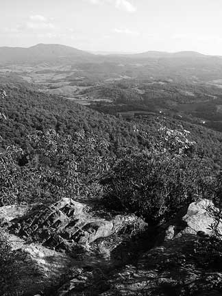
Then there’s Comers Rock. It stands by itself, northeast of the actual peak called “Mount Rogers.” Here, wooden rails mark the site of a long-gone lookout tower, built in 1928 atop the actual outcrop called “Comers Rock.”
To the north, Comers Rock overlooks the tree-topped mountains of Wythe County, folded like chunky waves on the endless horizon, high above Rural Retreat.
It’s just as unforgettable, but very different, looking south: Pockets of green curves appear in Elk Creek’s bowl between Buck Mountain, Point Lookout Mountain and the Iron Mountains of central Grayson County.
In early spring, frost clings to evergreens at Comers Rock. The white coating crusts the bluegrass, too, in the valley of the Comers Rock community, a farming hamlet where old stores stand along VA-658 and VA-672.
Comers Rock is a pretty place–though quite quiet– and framed by century-old farmhouses and dotted with cattle. The post office closed in 1962, and now the community, unfortunately, unlike the rock itself, hardly finds its way on maps.
WHO IS COMER?
Well, one theory suggests the name “Comers Rock” originates from a man named Comer who evaded serving in a particular war by using this mountaintop rock as a hideout. Another story says the rock was simply named for the many Comers who settled in north-central Grayson County. These days, it’s probably harder to drive to Comers Rock – the lookout – than it is to finally just get out of your vehicle and walk to the overlook.
Just picture a rough road – mostly dirt and rutty. It follows up to a circular drive. From there, it’s only about a 150-yard hike, climbing stone steps, to reach Comers Rock.
Going back down the entrance road and turning east, you’ll reach the Comers Rock Recreation Area – a primitive campground and picnic site. It is among the least-used facilities in the entire Mount Rogers National Recreation Area.
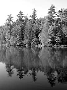
Go almost two miles west of Comers Rock Recreation Area and you’ll see Hale Lake, a five-acre fishing hole where minnows and tadpoles feed along forested banks. This lake is sometimes stocked with trout.
Hale Lake, too, offers a rewarding, though short, hiking experience.
Measuring less than a mile, a shoreline trail encircles the lake.
Easy to follow and well-suited for children, this path rambles over tree roots and clings close to a marsh thicket. It passes across a few bridges, built to protect hikers’ feet from muddy streams. It also slips past many good-looking fishing holes. Every 200 yards or so, the trail offers another view of the water. Hale Lake is not only popular for those wanting to wet a lure. It is also a great springtime picnic place.
Comers Rock and Hale Lake
HIKING LENGTH: About one mile
WHERE TO START: Hale Lake trail is about one mile. Comers Rock Trail is about 150 yards from the parking area.
TO GET THERE:From US-58 in Independence, follow US-21 north for about 14 miles. Turn left on USFS-57 (Hales Lake Road) at the Grayson-Wythe county line and head west for 3.6 miles to the campground. Continue west for a quarter-mile to the Comers Rock Overlook road on the right; it leads a quarter-mile uphill to a circular driveway, where stone steps reach the overlook platform within about 150 yards. To find Hale Lake, drive 1.5 miles west of the overlook road on USFS-57 to a gravel parking lot.
PARKING: No fee required.
DURATION: The hiking is easier than the driving. Most of your time will seem like it’s being spent on dusty roads, just trying to get there. Drive slowly – especially on the road leading to Comers Rock.
INFO: (800) 628-7202
Related Articles
Latest News

Leave a comment
Your email address will not be published. Required fields are marked *


Glad you enjoyed it! Grayson County is a jewel. Check out Morningside Farmhouse and Meadows, a beautiful Airbnb in Elk Creek, if you want to roam verdant open pastures with your kids and dogs.
We just got back for a long weekend! It is a great place. Very secluded. Very Very secluded. We stayed at the Forest Service owned Blue Spring Cabin about 3 miles from Comer’s Rock. It is a gem. On top of the mountain with amazing views. No running water, heat or ac but a flushing toilet, bonus.