Water rushes along Bottom Creek in Montgomery County, Va. Photo by Dana Blackmer/The Nature Conservancy
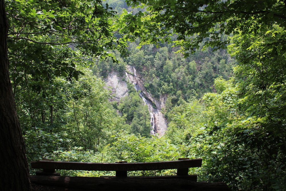
Tucked away in Montgomery County, Va., is a wonderful natural treasure called Bottom Creek Gorge Preserve. In addition to hiking trails, this place is home to the globally rare chestnut lip fern, old growth hemlock forest and Bent Mountain Falls, the second highest waterfall in the state. The falls empty into Bottom Creek, a Tier III waterway. Tier III waters are defined by Virginia as exceptional bodies of water that meet strict criteria. Protection of these creeks and rivers is crucial. Given the designation of Bottom Creek, it might be surprising to learn that the 42-inch fracked-gas Mountain Valley Pipeline threatens the pristine waters of the Bent Mountain community surrounding the preserve.
A drive through the quaint and picturesque community of Bent Mountain, down curvy mountain roads past apple orchards and a winery brings you to the preserve. The Nature Conservancy, a global land conservation nonprofit, began its acquisition of the 1,657 acres in 1988. Appalachian Power donated the 74 acres with Bent Mountain Falls in 1992.
The preserve presently has about 5 miles of hiking trails divided into three separate paths. The trails can be completed as an out-and-back hike or a combination of loops. I previously hiked the Johnston Trail with my eight-year-old grandson, who greatly enjoyed it. The hikes are not too strenuous and are suitable for families. This time, I chose to hike the Knight Trail, take a side excursion on a spur of the Johnston Trail to the falls overlook and complete my hike out on the Duval Trail. An entrance road leads to all three trails.
From the parking lot, head through a turnstile and down the entrance road. Here, one of the first things that hit me was the lush rhododendrons and the wonderful fragrance of the damp woods. Temperatures here run a few degrees cooler than the Roanoke Valley, so bring layers. When I hiked, my vehicle thermometer registered about a 10-degree difference!
About half a mile in on the entrance road, the Knight Trail, blazed in yellow, appears on the left. A short way down this trail, you will see a small pond on your right. I had the entire place to myself and found it very serene. Shortly after passing the pond, you will hear the sound of “the kettles” before you see them. The kettles are a series of broad-basin waterfalls formed as Bottom Creek makes its way into the gorge. Just over halfway down the Knight Trail, a short spur leads to Bottom Creek and the kettles. Be sure to pause and enjoy the beauty of this spot! There are ample flat spaces to sit, have lunch and enjoy the pristine nature.
Bottom Creek is a habitat to four rare aquatic species — the orangefin madtom, the bigeye jumprock, the riverweed darter and the Roanoke darter. Ten percent of all fish species found in Virginia can be found in these waters. I spent a good hour listening to the sounds and taking in the scenery.

An overlook allows hikers to view the state’s second-highest falls. Photo by Glenna Goldman/The Nature Conservancy
To complete my hike, I returned back up the Johnston Trail a short distance and turned left on the blue-blazed Duval Trail, which is rather plain and unassuming after the falls. Of all the trails, it is probably the easiest in terms of elevation gain. The path runs through mixed hardwood and evergreens with areas of thick, brambled underbrush. About halfway to the entrance road, the log remains of an old cabin stand just off the trail, and a bit further up is an old cemetery on the left. It was quiet and eerie the day I hiked. The wind was blowing through the pines and I could almost imagine ghostly voices chattering. Here, the trail runs through evergreen forest and fields until you reach the entrance road and head back out.
The hike here really gives one an appreciation for the natural beauty of this unique area. Given the status of Bottom Creek, it’s easy to see why so many would want to protect it and other natural resources from the potential damage caused by the construction of a 42-inch fracked-gas pipeline.
While the Mountain Valley Pipeline may not cross this preserve directly, MVP has repeatedly allowed excess sedimentation in nearby waterways, such as the Roanoke River and Little Teel Creek. Instead, the waters and lands surrounding areas such as the preserve should be cherished and protected for future generations to enjoy.
Bottom Creek Gorge Preserve
Length: Preserve contains over 5 miles of trails
Difficulty: Moderate
Directions: From I-81, take Exit 141 to Salem. Drive 8 miles south on Route 419 to Route 221 at Cave Spring. Take winding Route 221 south for 13.8 miles to Route 644. Turn right on Route 644. After 1.1 miles, veer to the right on Route 669 and drive for 2.3 miles. After 1.5 miles, bear right. Cross a bridge after 1.3 miles, turn left at the preserve sign. Park on the side of the road at the gate.
Contact: Call the conservancy at (434) 295-6106 or visit tinyurl.com/BottomCreek
Other Notes: Open from dawn till dusk. Dogs, fishing and picking plants and mushrooms are not allowed.
Related Articles
Latest News

Leave a comment
Your email address will not be published. Required fields are marked *


Leave a Comment