By Joe Tennis
Our goal was to roam from the road to the ridge, taking in terrain that would change from sidewalks to soil with sticks and stones.This pedestrian journey with my 12-year-old son, John, began just off the combined routes of U.S. 11/19 on the north end of Bristol, Va., at Sugar Hollow Park.
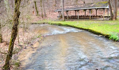
Spanning about 400 acres, Sugar Hollow is a diverse recreation spot on the north end of Bristol. The park contains about a dozen miles of trails ranging from a creekside ramble with tiny rapids between a picnic area and campground to a sedate figure-eight slate of sidewalks fronting the fabled Lee Highway amid ballfields and a large playground.
In other words, anyone can find a place to walk – or hike – here.
On a brisk Friday, John and I followed those sidewalks to the stony woods where few go.
Hiking at Sugar Hollow Park
Trail length: Choose from roughly 12 miles of trails
Difficulty: Easy to moderate
Address: 3600 Lee Highway, Bristol, Va.
Contact: Call (276) 645-7275, and find a map of the trails here
We started at the main parking area, just beyond the entrance and just below the Beaver Creek Dam, a grassy hill built in 1965 by the Tennessee Valley Authority. That dam holds back Beaver Creek with a dry retention basin sometimes erroneously listed on maps as “Beaver Creek Lake.” In reality, there is no lake – just a giant ravine prone to flooding.
From the parking area, we followed the sidewalk along the entrance road to the top of the dam for about a quarter-mile then took a left atop the dam and followed a simple up-and-back to take in the view. The top of the dam overlooks the Exit 7 commercial area of Bristol, with a wealth of shops, restaurants and hotels along I-81. Or, turning another way, you can look down into the wetlands, behind the dam, inside that big ravine to the deep woods that make Sugar Hollow such a sweet retreat.
After our up-and-back, we returned to the trail and veered left on a downward slope for another quarter-mile, crossing a footbridge before reaching the Beaver Creek Wetlands.
Perhaps the crown jewel of the park, the wetlands were constructed about 15 years ago in an often-flooded area. Maintenance crews added gravel trails outlined by chains and wooden walkways — including a 700-foot-long footbridge -—so that visitors can observe turtles, ducks and crayfish in a natural habitat.
Ponds in the wetlands hold overflow beside the main channel of Beaver Creek, a 21-mile-long waterway that begins on the outskirts of Abingdon, Va., and ultimately drains into Boone Lake in Northeast Tennessee.Again, we do an up-and-back through the wetlands, following that footbridge. This marks one of our excursion’s visual and audio highlights, hearing frogs and crickets singing some soulful swamp music.
Returning to the wetlands trail, we continue for another quarter-mile, eyeing the meandering stream beside another overflow pool.
We leave the wetlands, turn right on a trail, go about 20 yards then turn left on the sidewalk by the road. This sidewalk turns to a trail before passing a picnic shelter, at right. Cross the 20-foot-long footbridge above Beaver Creek and bear left on the road for another 100 yards, aiming straight for the Lions Club Shelter. At left, stairs head uphill at the start of the Ridge Trail.
Mountain Biking at Sugar Hollow
The wooded trails at Sugar Hollow Park serve both hikers and mountain bikers. Marked by their difficulty level, many of the trails were built with the assistance of the Southern Off-Road Bicycle Association’s Tri-Cities chapter.
The biking trails attract riders of all ages, according to Danny Hill, recreareation superintendent for Bristol, Va. For several years, the city’s King University has helped sponsor a collegiate championship race at Sugar Hollow.
In June 2018, the park hosted the Sugar Rush XC Mountain Bike Race, which raised money to help sponsor youth biking in the Tri-Cities. Science Hill High School in nearby Johnson City, Tenn., established Northeast Tennessee’s first National Interscholastic Cycling Association team in 2017, and bike enthusiasts are looking to build a team in Bristol and the surrounding area.
Even in cold weather, a dedicated group of riders meets weekly at the park, according to Hill. Sugar Hollow plans to release a new map in spring 2019 with updated information about the mountain biking trails. — By Molly Moore
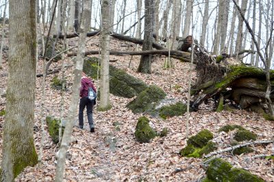
The moderately difficult Ridge Trail requires a steady ascension on its first quarter-mile as the sound of traffic on I-81 yields to the noise made only by the crinkly leaves and crunch of rocks beneath your boots.
John likes the climb. He’s huffing and puffing at first, then zooms ahead of me, refreshed with adrenaline, as we are transported to what seems like another world.
We ascend the ridge, finding ourselves in leafy woods among fallen logs and gray limestone rock outcrops. This ridge forms a natural barrier between the watersheds of Beaver Creek, which runs through the park, and Clear Creek, which cuts through a community called Wallace.
Suddenly, we hear the afternoon train’s echoing whistle from Wallace, though we cannot see any tracks as we continue meandering along the Ridge Trail to our final destination.
After about three-quarters of a mile beyond the Lions Club shelter, we turn left on the Whitetop View Trail, which is said to afford a view of Virginia’s two highest peaks: Whitetop Mountain and Mount Rogers. We did not see either. But we did follow that trail further up the ridge for about a half mile to its intersection with the Cave Loop Trail.
At that point, with the sun sinking, we reluctantly took an about-face and returned on the route from which we came, saving any further exploration of the park’s tiny cave for yet another exciting day of hiking the highlands of Sugar Hollow Park.
Joe Tennis is the author of 10 books, including “Along Virginia’s Route 58: True Tales from Beach to Bluegrass,” which features a chapter on Sugar Hollow Park.
Related Articles
Latest News

Leave a comment
Your email address will not be published. Required fields are marked *




Leave a Comment