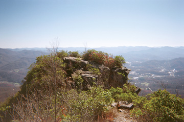
At Pinnacle Park’s namesake viewpoint, hikers can enjoy both a mountain panorama and a lofty view of nearby Sylva, N.C. Photo by Molly Moore
By Molly Moore
Pinnacle Park lies less than three miles from North Carolina’s oft-traveled Great Smoky Mountains Expressway. Unannounced by roadside signs, its network of trails explores the lookouts, ridges and valleys surrounding bubbly Fisher Creek. The creek’s headwaters, formerly the town of Sylva’s drinking water supply, are also the reason why these 1,100 acres are protected for public enjoyment.
Today, Pinnacle Park features about 15 miles of trails, ranging from strenuous to easily accessible. Five campsites provide solitary settings for backcountry users, but most visitors come for the varied day hikes, particularly the treks to the park’s two prominent overlooks.
The strenuous 3.5-mile path to the park’s namesake viewpoint, the Pinnacle, begins as an old logging road along Fisher Creek. As the main trail plows uphill on the west side of the creek, off to the right a separate half-mile trail gently meanders back and forth across Fisher Creek in an area that’s rich with seasonal wildflowers. “There are places where you’ll see trilliums blooming as far as the eye can see,” says park aficionado Jay Coward.
About a half mile from the parking lot, the trail diverges into the East Fork Trail and West Fork Trail, and Pinnacle-bound hikers typically head west. From here, it’s another half mile to Split Rock — a towering, unmistakable, cracked boulder.
Along the trail’s lower reaches, there are ample opportunities to relax on a rocky perch near the stream. Once the trail crosses Fisher Creek above Split Rock, it moves out of sight of the creek and begins to march upward; a backward glance through the leafless winter forest reveals a panorama of the Plott Balsams, a range within the Blue Ridge Mountains south of the Great Smokies.
By this point, hikers accustomed to more sedate trails might be wondering whether the old logging road’s relentless climb will soon subside. It doesn’t — not until the last mile.
At times, the wide trail is stubbornly rocky and rugged. Good hiking shoes are a must, and some adventurers might also want hiking poles, particularly in winter when the path can grow increasingly icy and snow-covered during the ascent. The steep trek makes this a lively winter warm-up, so hikers might want to bring a backpack to hold the layers they’re likely to shed during this portion of the hike.
Kirk Childress, store manager at Blackrock Outdoor Company in Sylva, advises hikers to plan for a temperature change of about 10 degrees from bottom to top. He also suggests that hikers give themselves ample time in case they are slowed down by the trail’s rough footing and sometimes-severe incline.
Those who make this trek should be grateful for the laborers behind the original logging road, the area residents who made the case for conserving this land, and the volunteers who built the present trail system — people like local lawyer Jay Coward.
Coward first hiked to Pinnacle Park’s Blackrock overlook at age 10. When new water regulations led the town of Sylva to stop using the Fisher Creek watershed as a drinking water source in 1990, several area residents, including Coward, formed Pinnacle Park Foundation, Inc., and advocated for the park’s formation.
At one point, the foundation received a request from the town board to harvest timber from the property, which the foundation denied — later, forestry students determined that removing timber wouldn’t be cost-effective. After that close call, the town and park foundation set up a conservation easement with the regional nonprofit organization Land Trust for the Little Tennessee to permanently protect the land.
Occasionally the bare winter woods reveal scattered stacks of downed, moss-covered trunks, hinting at the challenges that faced volunteer trail builders. “Back in the ‘70s, the balsam wooly adelgid arrived and started gobbling up mature Fraser firs,” Coward says. “[The pest] didn’t kill young Fraser firs, so when they had canopy openings they just sprang up through all this downfall. It was impossible to get through. We just had to chainsaw our way where the old trail was.”
About two miles from the trailhead, a sign marks the West Fork Trail’s split — from here it’s 1.4 miles to the Pinnacle, and 1.9 to Blackrock, another above-timberline rock outcropping. The popular overlook, and its 360-degree view of the southern Appalachians, is also accessible by a moderate hike from the Blue Ridge Parkway’s Waterrock Knob Visitor Center, or by taking the East Fork trail from the parking lot.
From the fork, the path to the Pinnacle levels off, hugging the mountain’s contours before exiting the tall forest and entering an expanse of rhododendron and mountain laurel. The trail appears to end amidst a stand of shrubbery, but a narrow, descending footpath breaks off to the left. It weaves through the rhododendron thicket and then opens to a wide view, with the Pinnacle protruding from the mountain like the bow of a ship.
The Pinnacle offers a 280-degree view of the Plott Balsam range, with the town of Sylva nestled among the forested mountainsides. “It’s not as high [as Blackrock], but it’s more intimate,” Coward says of the viewshed. “You feel like you’re more in a community from the Pinnacle.”
—————————————–
Pinnacle Park
DIRECTIONS — From US 74 W/Great Smoky Mountains Expy., turn right onto Steeple Rd. Make a quick right onto State Rd. 1527, then a left on Old 19-23/Skyland Dr. After half a mile, turn left on Fisher Creek Rd. Park is at the end of Fisher Creek Rd.
LENGTH —Reaching the Pinnacle via West Fork Trail is 3.5 miles; the park has 15 miles of trails
Info: (828) 586-2719
Related Articles
Latest News

Leave a comment
Your email address will not be published. Required fields are marked *


Leave a Comment