2012 — Issue 1 (Feb/March)
It’s Not My Mountain Anymore Review
Barbara Taylor Woodall, a distinguished writer and Appalachian native, tells the gripping — and sometimes humorous — story of her life growing up in the heart of the Georgia Appalachians in “It’s Not My Mountain Anymore.” Woodall was born in 1954 and raised in a family that maintained a very traditional Appalachian farm life. From…
Read More“The Day Baby Brucie Died”: An Oral History of the Buffalo Creek Flood
by Betty Dotson-Lewis Author’s note: Larry Conn is a Freewill Baptist Preacher, a public school teacher in Logan County, West Virginia, and a member of a gospel singing group. The oral history of Buffalo Creek Flood survivors such as Larry Conn may have been told repeatedly, but with each time it is relived. Forty years…
Read MoreHooded Crane
In an extraordinary story of “taking the long way ‘round,” a bird from the other side of the world paid a visit to the Hiwassee Wildlife Refuge in eastern Tennessee, shortly before the New Year. Jeffrey Davis drove 12 hours from Chester County, Penn., to take this photo of the Hooded Crane, a 3-foot tall…
Read MoreWe Can End Mountaintop Removal in Tennessee
By Dr. Minnie Vance Chattanooga, Tenn. In Tennessee, we love our mountains. These peaks and valleys inform our southern heritage, enhance our connection to family and represent the best of what we call state and country. Our mountains are home. Nevertheless, we too are facing down the barrel of continued mountaintop removal mining. Unfortunately, in…
Read MoreNatural Gas: Not All It’s Fracked Up To Be
By Jesse Wood When energy industry giant Halliburton invented hydraulic fracturing in the 1940s, they unlocked the potential for a natural gas boom in the United States. Now, decades later with mounting environmental and health impacts and more accurate estimates of the nation’s reserves, some feel natural gas isn’t all that it’s fracked up to…
Read MoreReclaiming Appalachia: Can Legislation and Enforcement Restore Mountains?
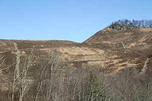
By Molly Moore Kathy Selvage has lived in Stephens, Va., her entire life. From her front porch, she can almost see the field where her childhood home once sat. Instead of the hardwood forest that surrounded her home, graded hills lean against each other like a lumpy bag of onions beneath a blanket of savannah…
Read MoreThe Sewanee Coal Seam: The Dirt on East Tennessee’s Toxic Coal
By Jenni Frankenberg Veal One of the most toxic coal seams east of the Mississippi River has cast a dark shadow over the land and people living in its boundaries. Landon Medley, a resident and former county commissioner of Van Buren County, Tenn., has witnessed the impacts of mining in the Sewanee coal seam firsthand.…
Read MoreRemembering Buffalo Creek
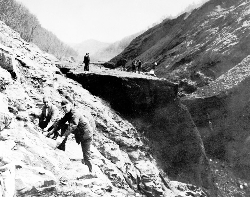
By Brian Sewell In the morning of Feb. 26, 1972, nearly 132 million gallons of water and coal waste rushed from Buffalo Mining Company’s slurry impoundments through Buffalo Creek Hollow, Logan County, W.Va. The flood coursed through 16 coal mining settlements along the creek where hundreds of families lived, while children slept or watched cartoons…
Read MoreNuclear Confusion
The Complicated History of the Atom in Appalachia By Paige Campbell Nuclear Fuel Services, Inc. sits on 66 acres between the Nolichucky River and the south end of Erwin, Tenn. This part of Erwin is the very picture of a small, blue-collar town. Within a quarter-mile of the fence surrounding the industrial site, there’s a…
Read MoreIs There A Kumbaya Moment Coming for the National Forests?
By Randy Johnson As wildflowers and buds break out this spring in the Southern Appalachians, hope that a greener fate for federal forest lands will bloom as well. On Feb. 9, 2012, the U.S. Forest Service and a handful of public and private collaborators — not all of them very collaborative in the past —…
Read More