
AV's Intern Team | August 6, 2015 | 1 Comment
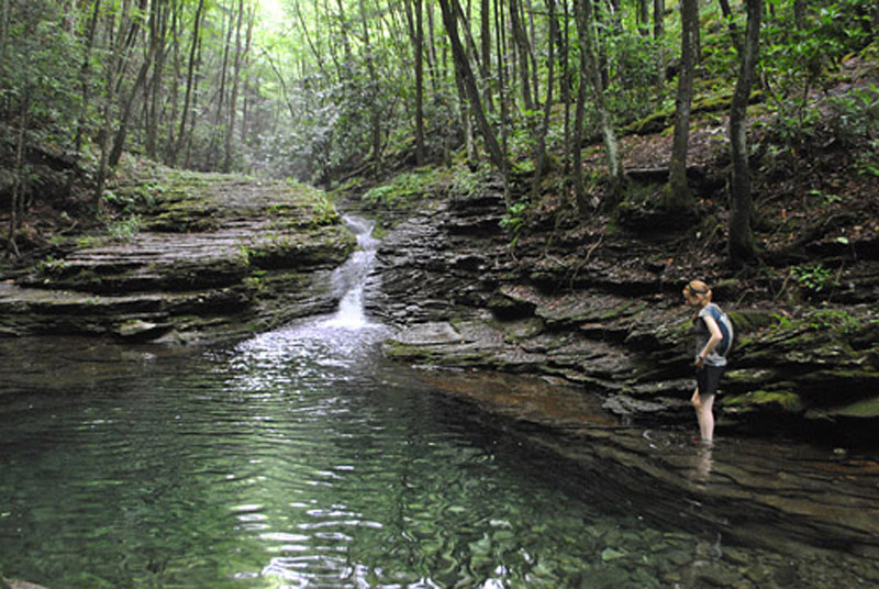
A resident of Big Island, Va., wades into the swimming hole on the Devil’s Fork Trail, which hikers encounter before reaching the Devil’s Bathtub. Photo by Joe Tennis
On a typical summer weekend, you can expect to find a crowd on the back roads of Scott County, Va., as dozens venture into the Jefferson National Forest near Fort Blackmore.
Destination: the fabled Devil’s Bathtub on the Devil’s Fork of Big Stony Creek — a natural wonder tucked away behind two tough trail miles.
What was once essentially a secret in southwest Virginia is now virtually a mainstream hangout, thanks to ever-spreading fame through YouTube videos and social media.
“It is a cool spot,” says Ishmael Richardson, Jr., the assistant park manager at nearby Natural Tunnel State Park.
Over time, the noisy waters of the Devil’s Fork have carved a hole about 20 feet long and eight feet wide in solid rock. Dubbed “The Devil’s Bathtub,” the name fits: the 12-foot-deep depression in the creek bed is shaped just like a bathtub, and a small waterfall drips into the basin like a faucet.
Problem: not everyone hiking here has prepared for the moderate — or even strenuous — hike that is required to reach this natural wonder.
“This is a hiker’s trail,” says Bill Cawood, a longtime interpreter for Natural Tunnel State Park. “It is not a groomed trail.”
The Devil’s Fork Trail makes a gradual uphill climb through a lush cove forest, says Cawood, a high school biology teacher in nearby Wise County, Va. “It’s high plant diversity and a unique micro-habitat. It’s rich soil, big trees.”
Want to hike? Come prepared with the proper footwear such as tennis shoes or hiking boots. Avoid flip-flops. But, you will get your feet wet. Over the roughly two miles it takes to reach the Devil’s Bathtub, you’ll step through running waters about a dozen times.
A gated road above the parking lot marks the start of the trail. From here, go about a quarter-mile and cross a stream.
“It’s easy to find the first stream crossing,” Cawood says. “And there’s where they seem to go wrong. Most people look at the right-hand fork of the trail, which seems to be a little more heavily used, and they go that way. That’s the wrong fork. The actual fork for the Devil’s Bathtub Trail is the left.”

Become a part of the Appalachian Voices’ network of advocates — sign up for action alerts and the our monthly e-newsletter The Advocate today!
Making that left, continue to follow the trail for about 20 yards. Then bear right and continue to follow the yellow-blazed trail as it goes up the creek.
Next, the trail makes its most dramatic crossing: it hops across a long row of rocks for about 60 yards in what appears to be a stream bed. Watch each step as you navigate this section and aim for a yellow blaze, marked on a tree, on the far bank.
Regaining level ground, look just beyond a small clearing to see an old, abandoned rail car. This rusty relic remains as evidence that this trail was once the path of a rail line hauling logs and coal.
From that rail car, the trail continues up the valley of the Devil’s Fork. It crosses the stream again and again for nearly another mile. Ultimately, the trail scales a small yet sometimes-slippery cliff on the creek’s left bank.
Just beyond the cliff lies the trail’s most popular point: the swimming hole.
“Lots of folks that I have brought up here thought we had achieved our goal when we got here,” Cawood says, pointing to the swimming hole. “They like the waterfall coming down into the swimming hole. This is what they expected.”
This is also where you’ll find a crowd when the temperature rises in the summertime. The creek runs cold year-round, and hikers like to take a dip in the cool waters.
The actual Devil’s Bathtub lies just about 100 yards beyond the swimming hole. At that point, though, most hikers turn back as the path grows more narrow and difficult to follow.
About once a month during the summer, Cawood leads guided hikes to the Devil’s Bathtub from Natural Tunnel State Park. “We have had nothing but positive comments and lots of thankful folks who told me that they would never have been able to come up here, find it or experience it without us helping them,” he says.
Joe Tennis is the author of “Virginia Rail Trails: Crossing the Commonwealth,” which features a chapter on the Devil’s Bathtub.
Difficulty: Moderate (includes stream crossings)
Length: About four miles (up and back)
Directions: From the intersection of State Routes 65 and 72 at Fort Blackmore, Va., follow SR 619 north for about 5 miles to the crossroads of SR 619 and SR 657. From here, turn left on SR 619 for about a quarter-mile. Then turn left on a gravel lane next to a white house. Follow this for about a half-mile to the parking area.
Guided hikes: Natural Tunnel State Park offers guided hikes to the Devil’s Bathtub once per month during the summer, weather permitting. View the schedule at dcr.virginia.gov/state-parks/natural-tunnel.shtml. Reservations are required by calling 276-940-2674.
Contact: Call the Clinch Ranger District of the Jefferson National Forest at 276-328-2931.
Like this content? Subscribe to The Voice email digests
2015 — (Aug/Sept)
 FERC extends MVP Southgate certificate for an additional three years
 Community celebrates opening of new recreation area in Dante, Virginia
 Dominion Energy’s lack of long-term planning remains clear as SCC proceedings conclude
 Appalachian Voices statement on Mountain Valley Pipeline’s receipt of key Clean Water Act permit
 ![]()
![]()
![]()
![]()
![]()

The Appalachian Voice is a publication of Appalachian Voices
589 West King Street, Boone, N.C.
© 2021 Appalachian Voices


 Member Spotlight: Russ Moxley
 Volunteer monitors coal mine data and maintains Appalachian Trail
 Creating Positive Change: A Note from Our Executive Director
 Solar, Environmental Justice and Utility Reform in Virginia
 Engaged activists get bipartisan wins in 2024 General Assembly session
 Investing in what matters: Federal funding to kick off community-led resiliency projects
 Opposition to new Dominion gas plant grows — and now includes Virginia state legislators
I dearly love beautiful waterfalls