
AV's Intern Team | April 16, 2013 | No Comments
Story and photo by Peter Barr

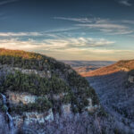
The view of Rabun Bald.
Two short hikes in northern Georgia’s Blue Ridge Mountains climb to the state’s highest peaks and reward visitors with its most stunning views. While the elevations of Brasstown Bald and Rabun Bald reign supreme in the Peach State, their picturesque scenery and fascinating cultural history are also difficult to surpass.
At 4,784 feet above sea level, Brasstown Bald — beaming with natural beauty — is the highest peak in Georgia, and offers both moderate and strenuous excursions.
A paved road east of Blairsville enables visitors to drive most of the way up the mountain. From a parking area south of the peak, a half-mile trail climbs the remaining distance to the summit. The paved path ascends steeply, gaining about 400 feet in elevation while tunneling through a forest of rhododendron and mountain laurel. Hike to the summit in late spring for the added bonus of its colorful blooms.
The summit of Brasstown Bald — surrounded by Chattahoochee National Forest — is crowned with a tall structure that looks much like an air traffic control tower. The lookout is occasionally manned by the U.S. Forest Service to provide rapid detection of forest fires in the surrounding national forest.
While the tower itself is closed to the public, an observation deck at its base affords hikers a 360-degree view of four states. On clear days, the skyscrapers of Atlanta are visible some 90 miles to the south.
Accompanying the observation deck is a small visitor center, open seasonally, that offers exhibits on the natural and cultural heritage of the mountain. The center’s motion-activated animatronic mannequins — which verbalize local lore — may be one of the most bizarre sights you ever encounter on a mountain hike.
What Brasstown Bald boasts in natural scenery, it matches in rich cultural history. For millennia, the mountain was frequented by Native Americans; hunting camps and petroglyph carvings have been discovered near the peak.
Hikers seeking a more challenging route may trek the 4.5-mile Jacks Knob Trail, which connects Brasstown Bald to the Appalachian Trail near Chattahoochee Gap, or the 5.5-mile Arkaquah Trail, which begins south of the town of Young Harris and links the summit to Trackrock Gap, the location of an archaeological petroglyph site. Both paths are designated National Recreation Trails.
When famed naturalist William Bartram passed near northern Georgia’s lofty Rabun bald in 1775, he wrote, “My progress was rendered delightful by the sylvan elegance of the groves, cheerful meadows, and high distant forests, which in grand order presented themselves to view.”
Georgia’s second-highest peak, at 4,696 feet, Rabun Bald is located 10 miles northeast of Clayton. To reach its summit, hike the Bartram Trail, the venerable footpath named in honor of the naturalist who was so enthused by the region’s scenery nearly 250 years ago.
To access the Bartram Trail from the trailhead at Beegum Gap, ascend steeply to the south on an unmarked but well-worn path. Climb through the hardwood forest until reaching a junction with the Bartram Trail, blazed with yellow rectangles, at 0.3 miles. Turn right and follow the Bartram Trail, climbing moderately to reach a roadbed crossing on the right at 0.8 miles.
Here, veer left to remain on the Bartram Trail and ascend up the steep and increasingly narrow ridgeline via a quick succession of switchbacks. The trail tunnels through a dense thicket of rhododendron, emerging at the summit of Rabun Bald at 1.5 miles.
Like Brasstown Bald, a fire lookout tower atop Rabun fosters a breathtaking view of the Blue Ridge range. The squat stone structure constructed by the Civilian Conservation Corps in the 1930s now hosts a wooden observation deck with a panoramic vista of the surrounding Chattahoochee National Forest. A keen eye can detect Brasstown Bald, 30 miles to the west.
“I beheld with rapture and astonishment a sublimely awful scene of power and magnificence, a world of mountains piled upon mountains,” wrote Bartram when he climbed the nearby Nantahala Mountains, visible just to the north. There is no doubt that his feeling of awe and wonder can still be experienced with a hike up Rabun Bald today.
Info: Chattahoochee National Forest (770) 297-3000
Getting There: From Blairsville, drive US 19/129 south 8 miles to GA 180. Turn left and drive 9 miles to GA Spur 180. Turn left and drive 3 miles to the park.
Length and Difficulty: Summit Trail, 0.5 mi, moderate; Jake Knob Trail, 4.5 mi., strenuous; Arkaquah Trail, 5.5 mi., strenuous.
Getting There: From Dillard, drive US 441 north for one mile. Turn right and drive 4.3 miles on GA 246 toward Highlands, N.C., to Old Mud Creek Road. Turn right and drive 2.9 miles to Kelsey Mountain Road. Turn right and drive 0.9 miles to the end of the road and trailhead at Beegum Gap.
Length and Difficulty: Reach the summit of Rabun Bald via the Bartam Trail in 1.5 mi., strenuous.
About the Author: Peter Barr is the trails & outreach coordinator at Carolina Mountain Land Conservancy, as well as the author of “Hiking North Carolina’s Lookout Towers.”
Like this content? Subscribe to The Voice email digests
![]()
![]()
![]()
![]()
![]()

The Appalachian Voice is a publication of Appalachian Voices
589 West King Street, Boone, N.C.
© 2021 Appalachian Voices


 Member Spotlight: Russ Moxley
 Volunteer monitors coal mine data and maintains Appalachian Trail
 Creating Positive Change: A Note from Our Executive Director
 Solar, Environmental Justice and Utility Reform in Virginia
 Engaged activists get bipartisan wins in 2024 General Assembly session
 Investing in what matters: Federal funding to kick off community-led resiliency projects
 Opposition to new Dominion gas plant grows — and now includes Virginia state legislators